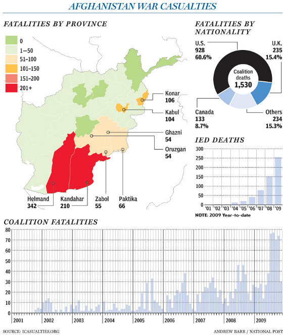
The National Post printed a good graphic on Coalition casualties, by province, throughout Afghanistan, as well as some attack statistics. Some items of note:IED deaths, at more than 250, have increased by more than five times since 2006. The US, Canada, and Britain are shouldering the brunt of the casualties; 84.7% of the deaths in Afghanistan are taken by these three countries. Coalition deaths have skyrocketed in the past year.
The graphic also provides an interesting, but limited view of the Afghan insurgency. Using Coalition casualties alone to gauge the nature of the insurgency would lead you to believe that the insurgency is by and large concentrated in southern Afghanistan, with spillover into southeastern Afghanistan. There is plenty of truth to this; the provinces of Helmand and Kandahar are the traditional power base for Mullah Omar and violence in the two provinces have been high.
But just because Coalition casualties are low in other regions, this does not mean the Taliban are no present, or even in control. For example, the Taliban control significant areas in the northern provinces of Kunduz and Baghlan; the western provinces of Farah, Nimroz, Badghis, and Herat; the northeastern province of Kunar; and the central provinces of Kapisa, Logar, and Wardak; and the eastern provinces of Khost and Paktia. But Coalition casualties are low in these areas (1-50 deaths since 2001). If you looked at the map and used Coalition casualties as the metric for the insurgency, you'd think the Taliban problem is minimal in these province. The same goes with Uruzgan, Zabul, Ghazni, Paktika, and Nuristan (each with 51-100 deaths), yet the Taliban also control vast regions in these provinces. In Nuristan, the US recently pulled out of some outposts, ceding control after the command recognized it could not control these regions with remote outposts.
http://www.longwarjournal.org/threat-matrix/archives/2009/11/coalition_casualty_map_masks_t.php