Democratic Underground Latest Greatest Lobby Journals Search Options Help Login
Google

Fuck. 42-43 feet

Printer-friendly format Printer-friendly format
Printer-friendly format Email this thread to a friend
Printer-friendly format Bookmark this thread
This topic is archived.
Home » Discuss » Archives » General Discussion (1/22-2007 thru 12/14/2010) Donate to DU
 
uppityperson Donating Member (1000+ posts) Send PM | Profile | Ignore Thu Mar-26-09 08:14 PM
Original message
Fuck. 42-43 feet
The rivers in ND and MN are flooding. The Red River (goes between Fargo and Moorhead) is expected to crest 2-3 feet HIGHER than the huge flood of 1997. Crap crap crap. If it gets that high, looks like the house I grew up in will flood too, and it is up a little bit. It is very flat there, water goes really far and being up or down a foot can make a huge difference.

There are several DUers in the area. Some have been posting here:
http://www.democraticunderground.com/discuss/duboard.php?az=show_mesg&forum=102&topic_id=3802208&mesg_id=3802208
http://www.democraticunderground.com/discuss/duboard.php?az=show_mesg&forum=102&topic_id=3797090&mesg_id=3797090
http://www.democraticunderground.com/discuss/duboard.php?az=show_mesg&forum=102&topic_id=3800775&mesg_id=3800775
http://www.democraticunderground.com/discuss/duboard.php?az=show_mesg&forum=389&topic_id=5334836&mesg_id=5334836


If anyone is in the area and wants to go help, or can get there, they need people to help sandbag and to do dike watches. They were preparing for 41 ft, trying to top it all off to be able to get there, now they are scrambling again.


http://www.inforum.com/ has lots of info and pictures.

http://www.inforum.com/event/article/id/235344/
SHOCKING DEVELOPMENT: Red River crest in Fargo raised to 42 feet, could even hit 43 feet

In a stunning blow, the National Weather Service has raised the crest prediction to between 41 and 42 feet – and potentially as high as 43 feet by Saturday for the Red River at Fargo-Moorhead.

The weather service said the crest could continue for three to seven days. The service’s Web site shows the river hitting 42 feet late Saturday. The current record is 40.1 feet in 1897.

The Red River read 39.43 feet at 5:15 p.m., rapidly rising as it approaches the 1997 crest of 39.57 feet.

“When we wake up tomorrow, it’s going to be … a foot and a half higher than it is now,” said Greg Gust, a weather service meteorologist. The river will top the 1997 level and likely reach 40 feet between midnight and 2 a.m. Friday, he said.


On a positive note, they blasted some ice damns on the Missouri and it looks like Bismarck is ok now.
Printer Friendly | Permalink |  | Top
annabanana Donating Member (1000+ posts) Send PM | Profile | Ignore Thu Mar-26-09 08:16 PM
Response to Original message
1. Aw shit...
I know everyone's mobilized.. I'm prayin' for you all.
Printer Friendly | Permalink |  | Top
 
bdamomma Donating Member (1000+ posts) Send PM | Profile | Ignore Thu Mar-26-09 08:18 PM
Response to Original message
2. please be careful, terrible situation.
Printer Friendly | Permalink |  | Top
 
uppityperson Donating Member (1000+ posts) Send PM | Profile | Ignore Thu Mar-26-09 08:22 PM
Response to Reply #2
5. Thanks, I am not there, moved out west, just got the family home sold last fall
I hope the people living there are hanging in there. It looks awful, snow storm and record flood. crap crap crap.
Printer Friendly | Permalink |  | Top
 
Sultana Donating Member (1000+ posts) Send PM | Profile | Ignore Thu Mar-26-09 08:20 PM
Response to Original message
3. I just called my family
I've told them to get ready to leave, I wish I wasn't so far away. :(


:cry: :cry: :cry: :cry: :cry: :cry: :cry: :cry:
Printer Friendly | Permalink |  | Top
 
uppityperson Donating Member (1000+ posts) Send PM | Profile | Ignore Thu Mar-26-09 08:25 PM
Response to Reply #3
6. Contingency evacuation plans...
Edited on Thu Mar-26-09 08:27 PM by uppityperson
http://www.cityoffargo.com/Flood09/
Part of the problem is not knowing how high it will go, and what will hold. They arrested a woman last night for standing on a dike taking pictures (they'd warned they would but she thought she could get away with it).

Another part of the problem is minor elevation changes can mean a lot. Here is a clickable map, go to "FEMA elevation" on drop down on right, then you can draw a box to go in to a particular area in Fargo. It is very interesting, but...

Best of luck to them

Printer Friendly | Permalink |  | Top
 
DemoTex Donating Member (1000+ posts) Send PM | Profile | Ignore Thu Mar-26-09 08:22 PM
Response to Original message
4. Cue the Lead Zepp ..
http://www.youtube.com/watch?v=ATrjEb9-nQ0

Man, I hope the sand bag levee holds. This is some bad shit.
Printer Friendly | Permalink |  | Top
 
geckosfeet Donating Member (1000+ posts) Send PM | Profile | Ignore Thu Mar-26-09 08:29 PM
Response to Original message
7. Isn't this supposed be a 50 or 100 year event? Seems like every 5-10 years
this river is overflowing it's banks.

Wasn't there talk about re-building farther from the banks last time it flooded?
Printer Friendly | Permalink |  | Top
 
uppityperson Donating Member (1000+ posts) Send PM | Profile | Ignore Thu Mar-26-09 08:36 PM
Response to Reply #7
8. That was Grand Forks, upstream to the north. They did move a lot of there.
Printer Friendly | Permalink |  | Top
 
laundry_queen Donating Member (1000+ posts) Send PM | Profile | Ignore Thu Mar-26-09 08:51 PM
Response to Reply #8
14. Both cities really should do the same thing
that Winnipeg did further upstream. They have a large floodway that saved the city in 1997. It's just basically a giant ditch to divert excess water around the city. Super costly but with climate change and a river that is already very prone to flooding it would probably be worth it. Think of the boost to the local economy as well. I wonder if they have considered it?
Printer Friendly | Permalink |  | Top
 
laundry_queen Donating Member (1000+ posts) Send PM | Profile | Ignore Thu Mar-26-09 08:55 PM
Response to Reply #14
18. oh, and I wanted to add...
I'm sending out good thoughts to everyone along the river right now. I have family in Winnipeg and am watching the whole situation closely - it really just plain sucks.
Printer Friendly | Permalink |  | Top
 
uppityperson Donating Member (1000+ posts) Send PM | Profile | Ignore Thu Mar-26-09 09:04 PM
Response to Reply #14
19. I don't know if they have. This yr's flood is a record breaking one, here's a graph...
This is expected to surpass all records that have been kept, thanks to record precipitation, including the 5 inches of snow that fell yesterday/today. It usually doesn't get like this. The highest recorded was 1897, next 1997

Printer Friendly | Permalink |  | Top
 
Strelnikov_ Donating Member (1000+ posts) Send PM | Profile | Ignore Thu Mar-26-09 11:32 PM
Response to Reply #14
31. Yep
http://maps.google.com/maps?q=winnepeg&oe=utf-8&client=firefox-a&ie=UTF8&hl=en&ll=49.876495,-96.986618&spn=0.213285,0.493698&t=h&z=11

Control structure on main stem regulates flow balance between natural channel and bypass.

This would have cost $1b at Grand Forks, so they went with $200m levee project.
Printer Friendly | Permalink |  | Top
 
uppityperson Donating Member (1000+ posts) Send PM | Profile | Ignore Thu Mar-26-09 11:46 PM
Response to Reply #31
34. Wow, that is a nice picture. Very cool.
A big ditch around the city. Interesting, thanks, I'd heard about it but had never seen it before.
Printer Friendly | Permalink |  | Top
 
uppityperson Donating Member (1000+ posts) Send PM | Profile | Ignore Thu Mar-26-09 08:38 PM
Response to Original message
9. Red River broke crest of 1997 flood at 7 p.m. tonight (will break record high midnight)
http://www.inforum.com/event/article/id/235345/
The Red River in Fargo-Moorhead now has reached 39.61 feet, edging past the 1997 crest of 39.57 feet.

That level was recorded at 7:15 p.m., the latest available.

Earlier today the National Weather Service revised its upper crest from 41 to 42 feet, with 43 feet possible, by Saturday.

The highest flood on record, in 1897, is 40.1 feet. The Red River in the metro area is expected to reach that milestone around midnight tonight.

"You're in uncharted territory, I guess," National Weather Service meteorologist John Hoppes said.
Printer Friendly | Permalink |  | Top
 
malaise Donating Member (1000+ posts) Send PM | Profile | Ignore Thu Mar-26-09 08:52 PM
Response to Reply #9
17. Unbelievable
Hugs for everyone in the path of the river. :grouphug:
Printer Friendly | Permalink |  | Top
 
Odin2005 Donating Member (1000+ posts) Send PM | Profile | Ignore Thu Mar-26-09 08:38 PM
Response to Original message
10. 43 feet now? Oh fuck.
And I was getting my hopes up because the crest was below what is predicted south of us. Crap.
Printer Friendly | Permalink |  | Top
 
uppityperson Donating Member (1000+ posts) Send PM | Profile | Ignore Thu Mar-26-09 08:39 PM
Response to Reply #10
11. Look up one post. Congratulations. fuck
broke 1997 record at 7 pm, expecting to break 1897 record at midnight.
Printer Friendly | Permalink |  | Top
 
uppityperson Donating Member (1000+ posts) Send PM | Profile | Ignore Thu Mar-26-09 08:49 PM
Response to Reply #10
13. Island Park permanent levee is 41.3 ft
AT 41.3 FEET AT FARGO...TOP ELEVATION OF THE ISLAND PARK PERMANENT LEVEE.
(found on http://weather.yahoo.com/storm/USND0115.html )

From above link...
DAILY 1 PM CDT/NOON CST FORECAST STAGE IN FEET:

DATE FRI SAT SUN MON TUE WED THU
(MONTH/DAY) 03/27 03/28 03/29 03/30 03/31 04/01 04/02

RED RIVER
FARGO 40.8 41.9 42.0 42.0 42.0 41.9 41.7


I feel sick. I am sorry. Please post tomorrow and the next wk to let us know how it is going, what can we do. Aside from being there to help you right now.

Printer Friendly | Permalink |  | Top
 
GreenPartyVoter Donating Member (1000+ posts) Send PM | Profile | Ignore Thu Mar-26-09 08:40 PM
Response to Original message
12. My heavens! That is just astounding. I hope everyone will be ok!
Printer Friendly | Permalink |  | Top
 
uppityperson Donating Member (1000+ posts) Send PM | Profile | Ignore Thu Mar-26-09 08:52 PM
Response to Reply #12
16. Live web cam, from Moorhead, MN across Red River towards Fargo
http://www.wday.com/news/index.cfm?id=9270

brrrr. Will probably look lighter when the sun is up, make more sense to people who don't know what they are looking at.
Printer Friendly | Permalink |  | Top
 
glinda Donating Member (1000+ posts) Send PM | Profile | Ignore Thu Mar-26-09 11:15 PM
Response to Reply #16
30. They blasted ice dams up on the Red River near Winnipeg earlier on and I
guess the Red flows North? But I would say that my guess is that the two events are related. Don't know but it seems interesting timing. Just wonder if this could have the result of the Red rising a bit higher than expected.
Printer Friendly | Permalink |  | Top
 
uppityperson Donating Member (1000+ posts) Send PM | Profile | Ignore Thu Mar-26-09 11:33 PM
Response to Reply #30
32. It does flow north, not sure if it was backing up that far.
I bet they are trying to make sure it keeps flowing up there. They blasted the Missouri near Bismarck also to get rid of a dam. Oh damn, I've been spelling it "damn" up 'til now. Which works also, damn ice dams.
Printer Friendly | Permalink |  | Top
 
upi402 Donating Member (1000+ posts) Send PM | Profile | Ignore Thu Mar-26-09 08:52 PM
Response to Original message
15. I heard that on Air America news break and it sucks! n/t
Printer Friendly | Permalink |  | Top
 
uppityperson Donating Member (1000+ posts) Send PM | Profile | Ignore Thu Mar-26-09 09:06 PM
Response to Original message
20. Evacuation notices: S Moorhead, between 1st line&contingency dikes in Fargo
http://www.inforum.com/event/article/id/235346/group/home/
Moorhead officials are directing that all residents who live between Interstate 94 and 50th Avenue South west of Eight Street to evacuate the area immediately. And Fargo officials are asking for voluntary evacuations for those who live between contingency and first-line dikes in the next 24 hours, saying it will become mandatory after that. Fargo city commissioners during a special meeting tonight passed a motion to shut down travel on all major roads in Fargo by midnight tonight.
Printer Friendly | Permalink |  | Top
 
wellstone dem Donating Member (1000+ posts) Send PM | Profile | Ignore Thu Mar-26-09 09:07 PM
Response to Original message
21. Our town is sending at least 6 more busloads of people
One school is sending 75 young men. When they called the bus company to hire the buses, the owner said, "you don't have to pay." It seems like everyone here in Minnesota is pitching in, every way they can.
Printer Friendly | Permalink |  | Top
 
uppityperson Donating Member (1000+ posts) Send PM | Profile | Ignore Thu Mar-26-09 09:11 PM
Response to Reply #21
23. Yea!!!!!!!!!!!!!!!!!
Printer Friendly | Permalink |  | Top
 
aquart Donating Member (1000+ posts) Send PM | Profile | Ignore Thu Mar-26-09 10:07 PM
Response to Reply #21
27. Bless them with success.
Printer Friendly | Permalink |  | Top
 
Patiod Donating Member (1000+ posts) Send PM | Profile | Ignore Fri Mar-27-09 09:15 AM
Response to Reply #21
49. Typical Minnesotans
Minnesota nice, writ large
Printer Friendly | Permalink |  | Top
 
uppityperson Donating Member (1000+ posts) Send PM | Profile | Ignore Thu Mar-26-09 09:11 PM
Response to Original message
22. Evacuation notices: S Moorhead, between 1st line&contingency dikes in Fargo
http://www.inforum.com/event/article/id/235346/

EVACUATION NOTICES: Southwest Moorhead residents directed to evacuate; Fargo residents living between dikes asked to voluntarily evacuate
Moorhead officials are directing that all residents who live between Interstate 94 and 50th Avenue South west of Eight Street to evacuate the area immediately. And Fargo officials are asking for voluntary evacuations for those who live between contingency and first-line dikes in the next 24 hours, saying it will become mandatory after that. Fargo city commissioners during a special meeting tonight passed a motion to shut down travel on all major roads in Fargo by midnight tonight.
Printer Friendly | Permalink |  | Top
 
uppityperson Donating Member (1000+ posts) Send PM | Profile | Ignore Thu Mar-26-09 09:21 PM
Response to Original message
24. EVACUATION NOTICES: Fargo evacuations directed; travel on major city roads to be shut down; sandbagg
EVACUATION NOTICES: Fargo evacuations directed; travel on major city roads to be shut down; sandbagging volunteers asked to work through the night
http://www.inforum.com/event/article/id/235370/group/home/
Officials here are asking for voluntary evacatuions for those between contingency and first-line dikes in the next 24 hours, saying it will become mandatory after that.

Also, Fargo officials issued a mandatory evacuation in the River Vili and Riverview Estates areas in South Fargo. There are 35-40 homes in the River Vili neighborhood. Riverview Estates is a senior living center. The Fargo Police Department, Fire Department and National Guard are on the scene assisting residents. The evacuation was determined necessary after longitudinal cracks were found in the earthen levy built to protect the area from flood waters. Residents are not in immediate danger but are being evacuated as a safety precaution until the situation can be assessed and appropriate measures can be taken.

Commissioners unanimously passed a motion to shut down travel on all major roads in the city by midnight tonight.

It is unclear whether Code Red is being used. Fargo City Administrator Pat Zavoral called the system "sketchy" during an ongoing meeting tonight.

The Fargodome and Sandbag Central will be open through the night. Authorities are asking people to get there dikes up to 44 feet in the next 24 to 48 hours, including working through the night if needed. Those needing sand or bags to be brough to their neighborhood should call (701) 241-1545....
Printer Friendly | Permalink |  | Top
 
AndrewP Donating Member (1000+ posts) Send PM | Profile | Ignore Thu Mar-26-09 09:21 PM
Response to Original message
25. It's time to have a mandatory shut down of business in the city
Being open leaves so many people on the roads, which slows up the emergency work.
Printer Friendly | Permalink |  | Top
 
uppityperson Donating Member (1000+ posts) Send PM | Profile | Ignore Thu Mar-26-09 09:41 PM
Response to Reply #25
26. From what I am reading, looks like they are asking people to
Edited on Thu Mar-26-09 09:42 PM by uppityperson
consolidate, stay home unless you are helping out. Looks like they are closing most roads tonight. "travel on major roads to be shut down". I agree they should call for a shut down for the next few days until the water starts to recede, in case something leaks or pops.

I hope you don't mind me posting all this, not trying to take over but just pulling info together so those who are there and busy don't have to.
Printer Friendly | Permalink |  | Top
 
uppityperson Donating Member (1000+ posts) Send PM | Profile | Ignore Thu Mar-26-09 10:23 PM
Response to Original message
28. MeritCare's Fargo hospitals evacuating patients tonight (ok, THIS freaks me out)
This is inland enough and I don't think it should flood. Better safe than sorry but this is freaky.

http://www.inforum.com/event/article/id/235372/
FARGO - MeritCare officials said tonight, that after consulting with local and state emergency officials, they are evacuating patients from all Fargo MeritCare hospitals of 8:30 p.m. tonight.
Printer Friendly | Permalink |  | Top
 
uppityperson Donating Member (1000+ posts) Send PM | Profile | Ignore Thu Mar-26-09 11:35 PM
Response to Reply #28
33. MeritCare (hospital) statment...
http://www.meritcare.com/About/MeritCareFeatures/View_Article.aspx?id=44
After consulting with local and state emergency services, to ensure the safest possible evacuation of patients from the city, MeritCare is initiating the evacuations of hospital patients as of 8:30 p.m., Thursday, March 26.

MeritCare Hospital and MeritCare South University Hospital are starting the process of evacuating hospital patients out of the Fargo-Moorhead area tonight.

MeritCare is working with local and state emergency operations centers to coordinate the safest transfer of patients to available hospitals that will be able to continue their required care. Some of the hospitals include Abbot Northwestern, Minneapolis, North Country Hospital, Bemidji, Minn., Sanford Health, Sioux Falls, S.D., and St. Alexius, Bismarck, N.D.

MeritCare's first priority is ensuring a safe and orderly transfer for patients and their families. MeritCare is communicating directly with patients and their families regarding their transfer and plan for continued care. Patients are being transferred by LifeFlight, ambulances and buses. Medical providers including physicians, nurses and EMT's are accompanying patients, depending on the level of care necessary for each patient. Necessary medical equipment and supplies are also being transferred with each patient.

The number of patients being evacuated is 180 and includes patients with care needs ranging from minor to critical.

The Emergency Center at MeritCare's downtown location will remain open. We will be stabilizing patients and transporting them to other hospitals.

On Friday, MeritCare Southpointe and West Fargo Clinics will remain open for primary care walk-in care only; all other primary care locations in Fargo-Moorhead will be closed. Walk-In Clinic, Children's Walk-In Clinic and Fast Track locations will remain open. The Infusion Center will be operating out of the South University Day Unit for scheduled patients only and out-patient dialysis will be open.
Printer Friendly | Permalink |  | Top
 
uppityperson Donating Member (1000+ posts) Send PM | Profile | Ignore Thu Mar-26-09 11:14 PM
Response to Original message
29. Police announce road closures for Friday
This means all the major throughways are closed. Wonder if they'll do martial law?

http://www.inforum.com/event/article/id/235378/group/home/
The Fargo Police Department has announced the closure of several roads that will be used for flood truck traffic only beginning at 6 a.m. Friday.

The closures are as follows:

- University Dr. from 35th Ave. N. to 40th Ave. S.

- 10th St. from 13th Ave. S. to 19th Ave. N.

- NP Ave. from University Dr. to the river

- 7th Ave. N. from University Dr. to the river

- 19th Ave. N. from University Dr. to Elm St.

The North Dakota National Guard will be assisting police at significant intersections to ensure the smooth flow of truck traffic and to block civilian traffic from using these roadways. Cross traffic will be allowed in a controlled manner.

Police are requesting the assistance of the public to ensure these critical roadways are kept open to allow flood fighting efforts to continue as rapidly as possible.
Printer Friendly | Permalink |  | Top
 
uppityperson Donating Member (1000+ posts) Send PM | Profile | Ignore Fri Mar-27-09 12:19 AM
Response to Original message
35. Begging here, 3 recs. Could we get 2 more?
Printer Friendly | Permalink |  | Top
 
MrSlayer Donating Member (1000+ posts) Send PM | Profile | Ignore Fri Mar-27-09 12:20 AM
Response to Reply #35
36. One more.
:kick:
Printer Friendly | Permalink |  | Top
 
uppityperson Donating Member (1000+ posts) Send PM | Profile | Ignore Fri Mar-27-09 12:30 AM
Response to Reply #36
37. thank you. I guess I don't write sexy enough subject lines
Printer Friendly | Permalink |  | Top
 
uppityperson Donating Member (1000+ posts) Send PM | Profile | Ignore Fri Mar-27-09 01:51 AM
Response to Original message
38. Evacuations in Fargo and Moorhead
Edited on Fri Mar-27-09 01:54 AM by uppityperson

http://www.inforum.com/event/article/id/235400/
Floodwaters forced residents to flee to higher ground Thursday in Fargo, Moorhead and the surrounding area, as forecasters warned that the Red River could reach a record 43 feet by Saturday.

In south Fargo, police, firefighters and National Guard members evacuated the Riverview Place senior living center and 35 to 40 homes in the River Vili subdivision after finding cracks in an earthen dike.

In Moorhead, city officials released a statement just before 8 p.m. directing all residents living between Interstate 94 and 50th Avenue South and west of Eighth Street to evacuate the area immediately. Minnesota law does not allow for mandatory evacuations, but Moorhead City Manager Mike Redlinger said residents were strongly urged to comply.
(clip)
City leaders requested a 24-hour voluntary evacuation of residents living between primary levees and backup dikes. Officials will reassess the situation today, and the evacuation could become mandatory, City Administrator Pat Zavoral said. Walaker thought the affected areas are home to about 1,000 residents. The North Dakota National Guard is prepared to evacuate up to 20,000 residents in the first phase of a mandatory evacuation, said Maj. Gen. David Sprynczynatyk.

Also, MeritCare officials said that after consulting with local and state emergency officials, they were evacuating patients from all Fargo MeritCare hospitals. The number of patients being evacuated to regional hospitals was 180, with conditions from minor to critical. ..(much more)
Printer Friendly | Permalink |  | Top
 
uppityperson Donating Member (1000+ posts) Send PM | Profile | Ignore Fri Mar-27-09 01:53 AM
Response to Original message
39. Why it is so hard to predict...

http://www.inforum.com/event/article/id/235395/
The Red River has consistently confounded forecasters trying to predict its flood peak. River watchers believed on Wednesday they had enough information to confidently predict the Red River will crest Saturday at 41 feet – a level that would surge well beyond the record 40.1-foot crest in 1897.

But Wednesday’s prediction was obliterated as more information came in, resulting in yet another crest prediction on Thursday – 42 or 43 feet in a crest expected to persist for three to seven days. “As the river exceeds the previous record level, the relative uncertainty in forecast models has increased significantly,” the National Weather Service announced.

One big problem is that the Red has shallow banks, making stage predictions difficult because stream gages can’t measure water that flows overland. Normally, forecasters’ grasp of the crest becomes clearer with each reading from instruments or field observers.

“Record flows upstream of Fargo have produced unprecedented conditions on the Red River,” the weather service advisory stated. “Given these factors, the river is expected to behave in ways never previously observed.”...(longer article@link)
Printer Friendly | Permalink |  | Top
 
Born_A_Truman Donating Member (1000+ posts) Send PM | Profile | Ignore Fri Mar-27-09 01:58 AM
Response to Original message
40. K&R Hoping for safety
I remember that American Inventor show a few years ago when one of the guys had a sand bag shovel. FEMA needs to buy a bunch of these and hand them out at times like this.

http://video.aol.com/video-detail/sackmaster-sandbag-shovel-sack-master-mark-martinez/6446772
Printer Friendly | Permalink |  | Top
 
me b zola Donating Member (1000+ posts) Send PM | Profile | Ignore Fri Mar-27-09 02:23 AM
Response to Original message
41. Best wishes for all
:grouphug:
Printer Friendly | Permalink |  | Top
 
uppityperson Donating Member (1000+ posts) Send PM | Profile | Ignore Fri Mar-27-09 03:10 AM
Response to Original message
42. Dike leak:evac for homes east of Fourth Street South between Lindenwood Drive and South River Rd
http://www.inforum.com/event/article/id/235422/group/home/
The Fargo Police Department issued a mandatory evacuation of all residences east of Fourth Street South between South River Road and Lindenwood Drive at 2:09 this morning. There has been a flood protection breech at Linden Avenue, east of Fourth Street South.

The neighborhood is just north of Lindenwood Park, a few blocks south of the city's water plant.

Due to the immediate threat of rising flood water, the City of Fargo is ordering a mandatory evacuation. Residents of this area of the city should immediately proceed west of the neighborhood.

Residents who do not have an alternative place to stay may seek emergency shelter at Fargo South Campus II (Agassiz). Additional shelters will be designated as needed. Residents should stay tuned in to WDAY AM 970 or connected to www.inforum.com for additional evacuation and temporary shelter information.
Printer Friendly | Permalink |  | Top
 
B o d i Donating Member (543 posts) Send PM | Profile | Ignore Fri Mar-27-09 03:11 AM
Response to Original message
43. Why doesn't Fargo have a floodway or ring dike or something yet? 1997 is so... 1997
Printer Friendly | Permalink |  | Top
 
uppityperson Donating Member (1000+ posts) Send PM | Profile | Ignore Fri Mar-27-09 03:18 AM
Response to Reply #43
44. This is the second highest flood in recorded history. Will make top soon they predict
It is an exceptional yr, exceptional flood. I am glad my aging parent moved away last fall.
Printer Friendly | Permalink |  | Top
 
uppityperson Donating Member (1000+ posts) Send PM | Profile | Ignore Fri Mar-27-09 03:22 AM
Response to Reply #43
45. Just broke record high flood.
http://www.inforum.com/event/article/id/235423/group/home/
n an unprecedented moment in recorded history, the Red River in Fargo this morning eclipsed the mark for its largest crest.

The Red River read 40.15 feet at 2:15 a.m., topping the previous mark of 40.1 feet set in 1897.

Floodwaters forced residents to flee to higher ground Thursday in Fargo, Moorhead and the surrounding area, as forecasters warned that the Red River could reach a record 43 feet by Saturday.

The river passed the 1997 flood crest of 39.57 feet just after 7 p.m. Thursday.
Printer Friendly | Permalink |  | Top
 
myrna minx Donating Member (1000+ posts) Send PM | Profile | Ignore Fri Mar-27-09 07:47 AM
Response to Original message
46. This is really bad. My heart is with my ND neighbors. K&R n/t
Printer Friendly | Permalink |  | Top
 
KharmaTrain Donating Member (1000+ posts) Send PM | Profile | Ignore Fri Mar-27-09 08:02 AM
Response to Original message
47. Excellent Local Radio Coverage...
http://www.kfgo.com/InternetRadio.asp

That's KFGO in Fargo-Moorehead. They were calling for sandbaggers this morning. This is also Ed Schultz's home station.

Printer Friendly | Permalink |  | Top
 
Spazito Donating Member (1000+ posts) Send PM | Profile | Ignore Fri Mar-27-09 08:35 AM
Response to Original message
48. Kicking back to the top...
This is very important, imo.

Recommended.
Printer Friendly | Permalink |  | Top
 
Flirtus Donating Member (500 posts) Send PM | Profile | Ignore Fri Mar-27-09 11:41 AM
Response to Original message
50. thanks for all the detail
Please keep us informed - sending warm & dry thoughts your way.
Printer Friendly | Permalink |  | Top
 
uppityperson Donating Member (1000+ posts) Send PM | Profile | Ignore Fri Mar-27-09 01:32 PM
Response to Reply #50
52. Thanks. I moved away yrs back, but have family/friends there.
Grew up in Fargo so know the area, what is where and minimal height differences of areas. This is hard, thanks.
Printer Friendly | Permalink |  | Top
 
uppityperson Donating Member (1000+ posts) Send PM | Profile | Ignore Fri Mar-27-09 01:31 PM
Response to Original message
51. Chart showing river level...
Printer Friendly | Permalink |  | Top
 
uppityperson Donating Member (1000+ posts) Send PM | Profile | Ignore Fri Mar-27-09 01:43 PM
Response to Original message
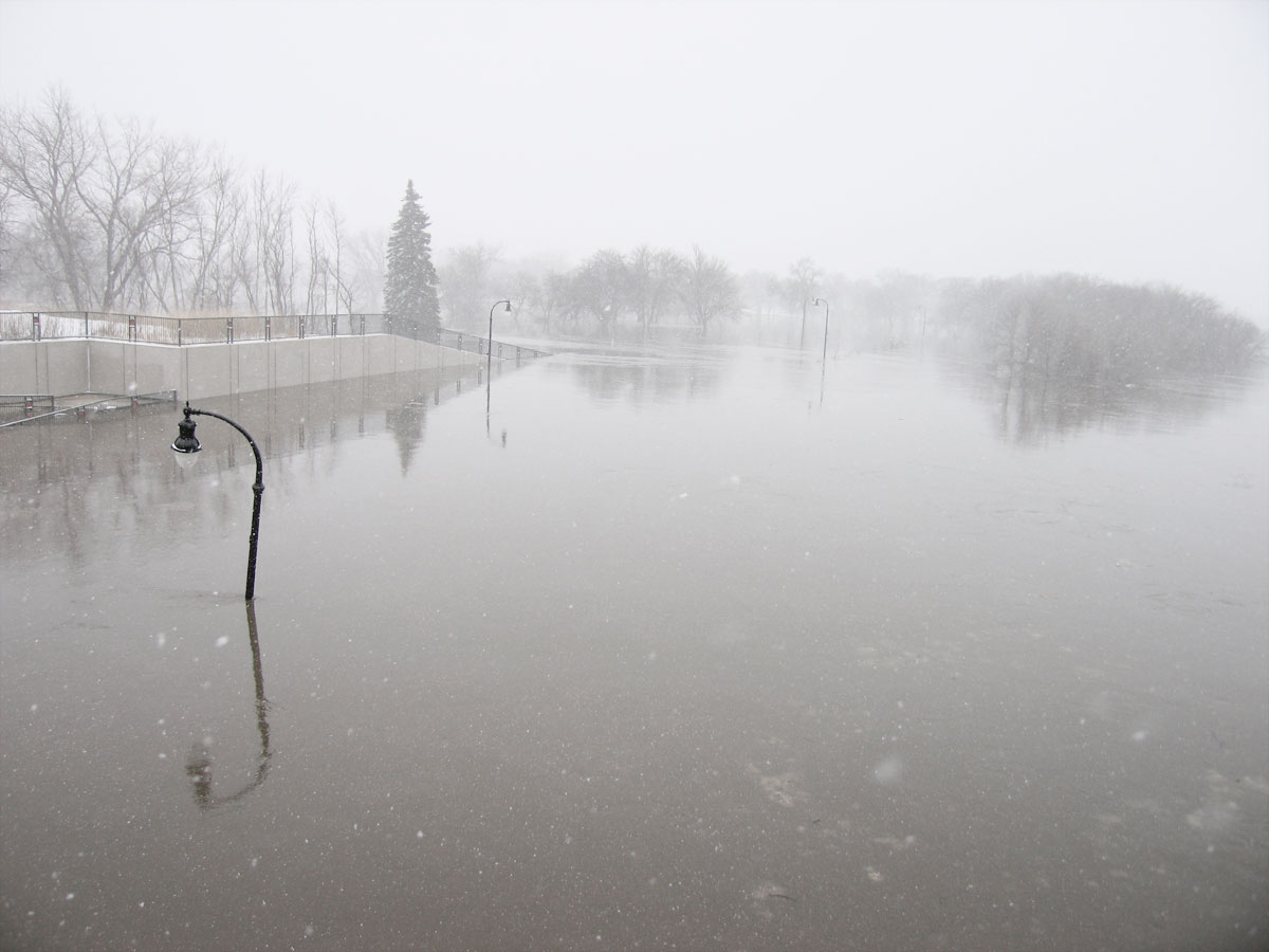
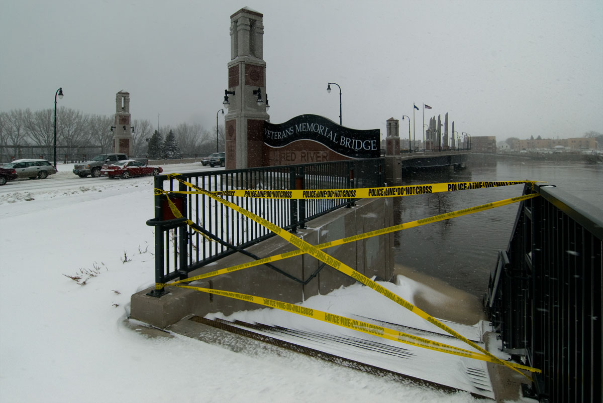
53. Bridge/river pictures
North 3rd St, Moorhead


Last open bridge between Fargo/Moorhead across the Red River


End of the block by my childhood home, which sold last fall. I never saw the river this high. Ever. Record flood going on. Argh, can't get the link to work. I inserted a space after "2009" If you copy/paste without the space, it will work.
http://www.ndsu.edu/fargo_geology/flood_photos/march_2009


/14th_ave_n_&_elm_st_fargo_nd2_39.6_ft_26-iii-2009_schwert_tn.jpg
Printer Friendly | Permalink |  | Top
 
Duer 157099 Donating Member (1000+ posts) Send PM | Profile | Ignore Fri Mar-27-09 02:14 PM
Response to Reply #53
57. thanks for the pics
Edited on Fri Mar-27-09 02:15 PM by Duer 157099
that link has some character that just won't work here, odd
Printer Friendly | Permalink |  | Top
 
uppityperson Donating Member (1000+ posts) Send PM | Profile | Ignore Fri Mar-27-09 02:21 PM
Response to Reply #57
58. Go to index, then to the picture (links, description)
Index http://www.ndsu.edu/fargo_geology/flood_photos/march_2009
pict is:
14th_ave_n_&_elm_st_fargo_nd2_39.6_ft_26-iii-2009_schwert.jpg
1.7 mb one is viewable, other one is tiny.

Thank you for looking.
Printer Friendly | Permalink |  | Top
 
uppityperson Donating Member (1000+ posts) Send PM | Profile | Ignore Fri Mar-27-09 01:59 PM
Response to Original message
54. Video, flyover of the Red River of the North
Printer Friendly | Permalink |  | Top
 
aikoaiko Donating Member (1000+ posts) Send PM | Profile | Ignore Fri Mar-27-09 02:04 PM
Response to Original message
55. talk about a shovel ready project.


good luck.
Printer Friendly | Permalink |  | Top
 
uppityperson Donating Member (1000+ posts) Send PM | Profile | Ignore Fri Mar-27-09 02:09 PM
Response to Original message
56. Elevations of Important Things...Now at 40.67 ft, headed to 42
http://www.crh.noaa.gov/ahps2/weekly.php?wfo=fgf&gage=fgon8&view=1,1,1,1,1,1,1,1&toggles=10,7,8,2,9,15,6
41.3 Fargo...Top elevation of the Island Park permanent levee.
40.2 Fargo...Top elevation of the emergency levees.
40.0 Fargo...Top of the Island Park dike. Moorhead...Red River is lapping at the base of the Heritage Hjemkomst Interpretive Center.
39.8 Fargo...Top of the Veteran Affairs Center dike.
38.2 Fargo...Convent Bridge at 52nd Avenue South is closed.
36.3 Fargo...Clearance height of 1st Avenue bridge.
35.0 Moorhead...Actions taken to prevent storm sewers from backing up.
34.4 Fargo...Northern-Pacific...Center Avenue bridge clearance.
34.0 Fargo...Sandbagging starts on dike near 15th Avenue and Elm Street North if the river is forecast to rise above 36.5 feet.
33.0 Fargo...Dike is constructed south of lift station to near 2nd Street and Main Avenue. Additional sandbagging on Elm Street dike near Woodland Drive. If river is forecast to rise above 37 feet, put extra earth on centerline of 10th Avenue South. 1979 Design top of dike at El Zagel golf course. Moorhead...Start diking to protect the Hjemkomst Center.
32.5 Fargo...Bridge at 1st Avenue and 2nd Street North closed for construction of temporary dike on 2nd Street. 1st Avenue North bridge across Red river closed for construction of temporary dike across 1st Avenue North. Moorhead...1st Avenue North bridge is closed.
31.0 Moorhead...1st Avenue North underpass is closed.
30.0 Major Flood Stage. Fargo...Flooding at 2nd and 3rd Avenue North areas. 2nd Street closed between Main Avenue and 4th Street. Temporary dike constructed to protect area within Oak Street dike; 58 feet South of 9th Avenue North. Moorhead...Water crosses entrance road to Gooseberry Mounds Park.
28.0 Fargo...12th Street toll bridge is closed. Construction begins on the dike to protect sewage treatment plant if forecast is above 34 feet. Moorhead...15th Avenue North river bridge is closed.
25.0 Moderate Flood Stage. Fargo...City Parks and Recreation areas along the river begin to flood.
24.0 Fargo...2nd Street closes between 1st and 3rd Avenue North for construction of temporary dike that protects City Hall if the river is forecast to rise above 31 feet.
23.3 Fargo...North Broadway bridge floods.
22.7 Fargo...Gage walls at Island Park are closed.
20.6 Fargo...North Broadway bridge is closed.
19.0 Fargo...Low-level dam south of Main Avenue is underwater.
18.0 Flood Warning Stage...minor. Fargo...North lane of Elm St between 14th and 15th Avenue is closed.
17.7 Fargo...Sanitary Sewers affected. Pump station at Island Park is started.
17.0 Forecast Service Stage. Fargo...Water rises to the edge of the bike path at El Zagel bowl along Elm Street North between 14th and 15th Avenues. Bankfull Stage.
Printer Friendly | Permalink |  | Top
 
AndrewP Donating Member (1000+ posts) Send PM | Profile | Ignore Fri Mar-27-09 02:38 PM
Response to Reply #56
59. K&R
Printer Friendly | Permalink |  | Top
 
uppityperson Donating Member (1000+ posts) Send PM | Profile | Ignore Fri Mar-27-09 02:55 PM
Response to Original message
60. crest forecast remains 41 to 42 feet Saturday, with 43 feet possible
http://www.inforum.com/event/article/id/235447/group/home/
The National Weather Service remains confident today in predicting a Red River crest of 41 to 42 feet in Fargo-Moorhead beginning Saturday, but allows for a possible 43-foot peak. That word came as forecasters are watching another storm system moving in from the west that could bring more snow to the area on Monday.

The track of the storm remains uncertain, but any snow would come at a time of sustained very high Red River levels through Fargo-Moorhead.

The WDAY forecast for Monday calls for a chance of snow, depending on the path of the system, and a high of 30 degrees. “A direct hit could result in several inches of snow,” according to the Web site. However, the cold snap that has settled over the valley, however, is helping to hold back flows into streams and rivers.

The result is the crest seems to have plateaued for a time today at 40.66 feet as the rate of increase has slowed....
Printer Friendly | Permalink |  | Top
 
uppityperson Donating Member (1000+ posts) Send PM | Profile | Ignore Fri Mar-27-09 04:13 PM
Response to Original message
61. Red's rise slows considerably after breaking record
http://www.inforum.com/event/article/id/235454/group/home/
The Red River’s rise in Fargo-Moorhead has slowed considerably today, which city officials said is an encouraging development in the fight against record high waters.

After passing the previous record of 40.1 feet at about 2 a.m. today, the river was at a height of 40.61 feet at 9:15 a.m., 40.64 feet at 11:45 a.m., 40.66 feet at both 12:15 and 1:15 p.m., and 40.72 feet at 3:15 p.m.

“It’s really flat right now,” Fargo Mayor Dennis Walaker said at a 2 p.m. press conference, adding that some people in southern areas of Fargo said the river level had been flat for three hours. “That’s all good news,” he said. “Whether it’s part of the temperature process, or whether it’s God’s intervention or whatever, it’s always good news that the river starts slowing down a little bit.”

City Commissioner Tim Mahoney said the city was going into dike monitoring mode. Sandbagging operations will cease at 6 p.m., and travel restrictions on major arterial roads will be lifted at that time, he said.
Printer Friendly | Permalink |  | Top
 
B o d i Donating Member (543 posts) Send PM | Profile | Ignore Sat Mar-28-09 12:49 AM
Response to Reply #61
64. Thank God for that cold snap, it really slowed the melting.
This could've been much worse. Much worse.
Printer Friendly | Permalink |  | Top
 
AndrewP Donating Member (1000+ posts) Send PM | Profile | Ignore Sat Mar-28-09 08:35 PM
Response to Reply #64
65. It's the greatest thing that could have ever happened!!!
Printer Friendly | Permalink |  | Top
 
AndrewP Donating Member (1000+ posts) Send PM | Profile | Ignore Sat Mar-28-09 08:38 PM
Response to Reply #61
66. Today was a good day, at least for one day.
They declared a "crest" today at around 40.86 feet.

It has actually dropped a few inches since this morning.

The city structure has held. Water and electricity are good right now in the actual downtown and "major" areas of Fargo and Moorhead.

We had a slight breach of the Main Avenue dike, which protects the only bridge between Minnesota and North Dakota in the city. So we were locked out of crossing cities for about 2 hours tonight.

Printer Friendly | Permalink |  | Top
 
uppityperson Donating Member (1000+ posts) Send PM | Profile | Ignore Sat Mar-28-09 10:58 PM
Response to Reply #66
67. Says they were upping the 2nd st dike? Hand in there, hoping it continues to stay cold and drop.
http://www.areavoices.com/springflood/?blog=47205
Second street dike widened; Main Avenue Bridge closed

At least 20 trucks loaded with clay lined Main Avenue and Second Street in Fargo around 6 this evening in preparation to widen the clay dike along Second Street.
"The Army Corps of Engineers just felt they needed to widen things here and needed to do it soon," said Fargo Police Captain Dave Todd, who helped direct traffic in the area.
Police stopped traffic eastbound on Main Avenue from Fourth Street to the Veterans Memorial Bridge and southbound on Second Street from NP Avenue. Fargo police also asked Moorhead police to stop bridge traffic on their end.
"We realize it's asking a lot because its one of only two corridors across the river," Todd said.
An official with the U.S. Army Corps of Engineers said there are no leaks; they are just shoring up the dike.


Picture of Moorhead, Hjelmkost in middle. Downtown Fargo in back.
Printer Friendly | Permalink |  | Top
 
glinda Donating Member (1000+ posts) Send PM | Profile | Ignore Fri Mar-27-09 11:59 PM
Response to Original message
62. All the Rivers from Little Falls MN to St. Cloud, Mn are very very high with trees
standing in the water. Not as bad as out West but rising. There will be some damage.
Printer Friendly | Permalink |  | Top
 
uppityperson Donating Member (1000+ posts) Send PM | Profile | Ignore Sat Mar-28-09 12:30 AM
Response to Reply #62
63. I feel for all in the cold and rising waters.
pain in the butt, best wishes to you and all
Printer Friendly | Permalink |  | Top
 
DU AdBot (1000+ posts) Click to send private message to this author Click to view 
this author's profile Click to add 
this author to your buddy list Click to add 
this author to your Ignore list Mon Apr 29th 2024, 01:49 PM
Response to Original message
Advertisements [?]
 Top

Home » Discuss » Archives » General Discussion (1/22-2007 thru 12/14/2010) Donate to DU

Powered by DCForum+ Version 1.1 Copyright 1997-2002 DCScripts.com
Software has been extensively modified by the DU administrators


Important Notices: By participating on this discussion board, visitors agree to abide by the rules outlined on our Rules page. Messages posted on the Democratic Underground Discussion Forums are the opinions of the individuals who post them, and do not necessarily represent the opinions of Democratic Underground, LLC.

Home  |  Discussion Forums  |  Journals |  Store  |  Donate

About DU  |  Contact Us  |  Privacy Policy

Got a message for Democratic Underground? Click here to send us a message.

© 2001 - 2011 Democratic Underground, LLC