EDIT
A different example, from the same time period, was the 1978 publication by the late John Mercer, Ohio State U., who argued that a major deglaciation of the West Antarctic Ice Sheet (WAIS) may be in progress within 50 years. This conclusion was based on the fact that the WAIS margin was ringed with stabilizing ice shelves, and that much of the ice sheet is grounded below sea level. The loss of ice shelves � Mercer proposed � would allow the ice sheet to thin, grounding lines to retreat and the ice sheet to disintegrate via calving. This is a much faster means of losing mass than melting in place. Mercer further commented that the loss of ice shelves on the Antarctic Peninsula, as has since been observed, would be an indicator that this process of ice sheet loss due to global warming was underway.
EDIT
Then, in 1998, Rignot (1998) used satellite imagery to identify that the grounding line of Pine Island Glacier had retreated 5 km from 1992 to 1996. In the same year, Wingham and others (1998) observed a 10 cm per year thinning in the drainage basins for Thwaites and PIG during the 1990�s. Shepherd and others (2001) noted thinning in the fast flow areas of the glacier of 1.6 m/year between 1992 and 1999. This led them to conclude that the observed inland thinning and acceleration of PIG was a response to enhanced glacier bed lubrication. Not from surface melting of course as there is next to none on this glacier. Rignot and others (2002) noted that the glacier had accelerated 18% over a 150 km long section of the glacier in the fast flow area between 1992 and 2000. Change was afoot: after 50 years of apparent stability, the glacier calving front was retreating, and the grounding line was retreating indicating reduced bedrock anchoring. The reduction in basal friction would then lead to faster flow and more thinning. Was this just a short-term increase?
In 2006 and 2007, instruments were placed directly on PIG for the first time by the British Antarctic Survey. Four GPS receivers monitored ice flow from 55 to 171 km inland of the calving front at the center of the glacier (Scott and others, 2009). Glacier velocities had been noted at each site in 1996; by 2007 the respective increase in velocity was 42%, 36%, 34% and 26% respectively, an approximately 2 to 3% annual increase. The increase from 2006 to 2007 was 6.4% at 55 km from the terminus and 4.1% at 171 km inland. The extent of the fast flowing portion of PIG is seen in the figure below. A separate data set, radar based was used by Rignot (2008) to identify a 42% acceleration of PIG between 1996 and 2007 accompanied by most of its ice plain becoming ungrounded.
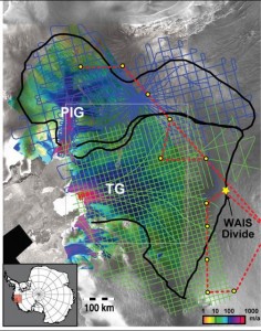
Velocity map of Pine Island and Thwaites Glaciers. Rignot, 2008
Scott and others (2009) pointed out that the greater thinning toward the grounding line and terminus increased the surface slope and the gravitational driving stress, further promoting acceleration. Then Wingham and others (2009) reported that the 5400 km2 central trunk of the glacier had experienced a quadrupling in the average rate of volume loss quadrupled from 2.6 km3 a year in 1995 to 10.1 km3 a year in 2006. PIG had an annual volume flux at the front of 28 km3 a year, so this increase is a marked change. Their observations were that the region of lightly grounded ice at the glacier terminus is extending upstream, and the changes inland are consistent with the effects of a prolonged disturbance to the ice flow, such as the effects of ocean-driven melting. Further examination of the bed topography by Vaughan and others (2006) indicates that most of the bed of the drainage basin of PIG is more than 500 meters below sea level, and there is a particularly deep basin in the eastern section of the upper basin. The observed acceleration, retreat of the grounding line, thinning of the lower section of the glacier and the observed elevation of the basal topography provide no indication that this is not a weak underbelly of WAIS.
The evidence does indicate that one of the basic underlying principles, proposed by Mercer and Hughes, of what can stabilize or destabilize WAIS was right on the money.
The evidence reviewed does not fully confirm the weak underbelly hypothesis, but it provides enough evidence that we had best monitor the situation and expand our attempts to understand it.Ed. - emphasis added.
EDIT
http://www.realclimate.org/index.php/archives/2009/11/is-pine-island-glacier-the-weak-underbelly-of-the-west-antarctic-ice-sheet/#more-1398