Democratic Underground Latest Greatest Lobby Journals Search Options Help Login
Google

Research Ship Polarstern Returns To Bremerhaven - Discovers Evidence Of Massive Sediment Movement

Printer-friendly format Printer-friendly format
Printer-friendly format Email this thread to a friend
Printer-friendly format Bookmark this thread
This topic is archived.
Home » Discuss » Topic Forums » Environment/Energy Donate to DU
 
hatrack Donating Member (1000+ posts) Send PM | Profile | Ignore Fri Oct-24-08 12:45 PM
Original message
Research Ship Polarstern Returns To Bremerhaven - Discovers Evidence Of Massive Sediment Movement
The German research vessel Polarstern has returned to Bremerhaven from the Arctic Sea. It has cruised as the first research vessel ever both the Northeast and the Northwest Passages and thereby circled the North Pole. The third part of the research vessel's 23rd Arctic expedition, operated by the Alfred Wegener Institute in the Helmholtz Association, started its journey on August 12th in Reykjavik and ended it on October 17th in Bremerhaven. The ship travelled a distance of 10.800 nautical miles, equivalent to 20.000 kilometres.

On board were 47 researchers from 12 nations, for example from Belgium, Germany, France, Japan, Canada, Korea, the Netherlands, Russia and the USA. Because of the small ice cover, the expedition members were able to research hitherto uncharted waters. The small sea ice cover presents a cause for concern regarding climate change in the Arctic Ocean. The aim of this expedition was to gather data on the development of the geology of the Arctic area.

The researchers around cruise leader Dr. Wilfried Jokat, geophysicist at the Alfred Wegener Institute, have discovered large sliding masses close beneath the seafloor of the East-Siberian continental shelf by means of sediment-acoustic parasound measurements. "Sliding masses are witnesses of great sediment relocations which appear, for instance, when large amounts of sediments are deposited", explains Jokat. The continental slope becomes unstable and sediments slide down. Such a large amount of sediments causing a shift can only have one reason: the sediments were frozen in the ice masses of the East-Siberian mainland, thawed during an interglacial and unloaded their sediments with the melt water into the ocean.

"This is a spectacular finding. Large-scale glaciations in eastern Siberia within the younger geological past of 60.000 years and older are so far unknown", explains Prof. Dr. Rudiger Stein, geologist at the Alfred Wegener Institute. Additional acoustic (seismic) data show that the East-Siberian Shelf was covered with ice over the last three million years only during a few glacial periods.


EDIT

http://www.terradaily.com/reports/Research_Around_The_North_Pole_999.html
Printer Friendly | Permalink |  | Top
Bigmack Donating Member (1000+ posts) Send PM | Profile | Ignore Fri Oct-24-08 05:28 PM
Response to Original message
1. This member of the Great Unwashed
would REALLY like to better understand the significance of this....but I haven't a clue! Is this information related to the stories of increased methane releases from the thawing, northern ocean floors? Help! Ms Bigmack
Printer Friendly | Permalink |  | Top
 
Barrett808 Donating Member (1000+ posts) Send PM | Profile | Ignore Fri Oct-24-08 11:05 PM
Response to Reply #1
2. I *think* it's evidence of past giant undersea avalanches when the permafrost thawed
Am I close?
Printer Friendly | Permalink |  | Top
 
happyslug Donating Member (1000+ posts) Send PM | Profile | Ignore Mon Oct-27-08 09:45 PM
Response to Reply #1
3. The Ice age Glaciers were MUCH larger in North America then Asia or Europe.
Edited on Mon Oct-27-08 09:51 PM by happyslug
This is showing that except for very brief time periods, Siberia and the Arctic Ocean off the coast of Siberia was ice free during much of the Ice Age, much more then North America.

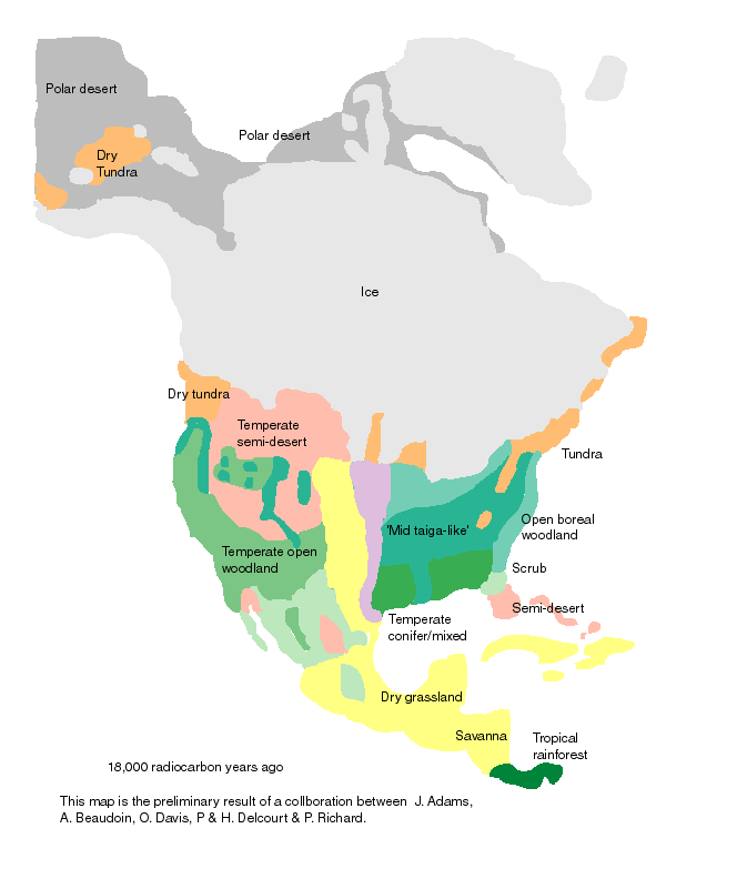
For example look at this map of North America 18,000 years ago:

http://www.esd.ornl.gov/projects/qen/nercNORTHAMERICA.html

Notice Alaska and the part of Siberia on that map are "Polar Deserts" NOT Covered by ice. In simple terms cold Tundra but almost no snow or ice. Which is strange given how far SOUTH the Glaciers were at that same time period.

This also affects oil exploration, if you look at about where the Alaska Oil Field is you will notice NO ICE. Further East in Canada where the Canadian Natural Gas Fields are located, you will see it was covered by ice, maybe up to a mile thick. Oil if it falls below about 20,000 feet, is converted to Natural Gas by the Heat of the earth. Thus the North Slope NOT being under Ice in the last Ice Age, has oil, while the Canadians fields, being pushed down further by the weight of the ice sheet over them, is Natural Gas. The arctic Wildlife preserve that the oil companies want to open up, is between the two fields, and could be more Natural Gas then oil depending on how far it sank do to the weight of the North America Ice Sheet to its east.

Compare the above with North America today:
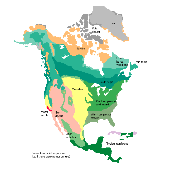

See how Siberia's Ice Sheet was smaller then North America even at the height of the Ice Age. See the following which has a good map of the two ice Areas and the Ice that covered them:
http://en.wikipedia.org/wiki/Ice_age

Here is a reference to a book about Siberian Ice Sheets (Probably more then you need, but interesting):
http://books.google.com/books?id=8CFiT3qbN5UC&pg=PA41&lpg=PA41&dq=Siberian+Ice+Sheet&source=web&ots=6VkbRJ_CkE&sig=BIafONXpIGyANNguBb_dMTz2GRg&hl=en&sa=X&oi=book_result&resnum=3&ct=result#PPA51,M1

In short, this may end the dispute of when Siberia became ice free and how long that occurred, this evidence supports only brief periods of Siberian Ice Sheets, which can explain why the waterway through the Arctic Ocean of Siberian has been Navigable since at least the 1930s (With the use of huge Ice breakers), while the North American North West Passage, is NOT usable commercially (Through some War Ships with Ice Breakers have made it through).
Printer Friendly | Permalink |  | Top
 
Bigmack Donating Member (1000+ posts) Send PM | Profile | Ignore Wed Oct-29-08 10:11 AM
Response to Reply #3
4. Thanks so VERY much for your post -
Can't say that now I TOTALLY understand, but at least now I have some hints and ideas, and I really really appreciate the time and effort involved in your post. I guess the bottom line, yet again, for me, is the sense of how critical our understanding of the past geology - natural history - of our home planet is to making informed policies about resource exploitation and use, but how fragmented our actual understanding is.....indeed how TOTALLY absent that understanding is from WAY TOO MANY OF US "OUT HERE" in the Great Unwashed. Scary thought..... But thanks again for your efforts - really appreciate it - Ms Bigmack
Printer Friendly | Permalink |  | Top
 
DU AdBot (1000+ posts) Click to send private message to this author Click to view 
this author's profile Click to add 
this author to your buddy list Click to add 
this author to your Ignore list Tue May 07th 2024, 12:41 AM
Response to Original message
Advertisements [?]
 Top

Home » Discuss » Topic Forums » Environment/Energy Donate to DU

Powered by DCForum+ Version 1.1 Copyright 1997-2002 DCScripts.com
Software has been extensively modified by the DU administrators


Important Notices: By participating on this discussion board, visitors agree to abide by the rules outlined on our Rules page. Messages posted on the Democratic Underground Discussion Forums are the opinions of the individuals who post them, and do not necessarily represent the opinions of Democratic Underground, LLC.

Home  |  Discussion Forums  |  Journals |  Store  |  Donate

About DU  |  Contact Us  |  Privacy Policy

Got a message for Democratic Underground? Click here to send us a message.

© 2001 - 2011 Democratic Underground, LLC