Democratic Underground Latest Greatest Lobby Journals Search Options Help Login
Google

Nazca lines. How? Why?

Printer-friendly format Printer-friendly format
Printer-friendly format Email this thread to a friend
Printer-friendly format Bookmark this thread
This topic is archived.
Home » Discuss » The DU Lounge Donate to DU
 
Jara sang Donating Member (1000+ posts) Send PM | Profile | Ignore Tue Aug-08-06 01:09 AM
Original message
Nazca lines. How? Why?
The question I have, were those ancient people able to look at those designs? From the air, somehow?:tinfoilhat: Maybe they could see them from a mountain top. I don't know.

Printer Friendly | Permalink |  | Top
GregW Donating Member (1000+ posts) Send PM | Profile | Ignore Tue Aug-08-06 01:12 AM
Response to Original message
1. It's an ancient airport - yeah, that's the ticket
(Dusting off his old copy of Chariots of the Gods)
Printer Friendly | Permalink |  | Top
 
BelleCarolinaPeridot Donating Member (1000+ posts) Send PM | Profile | Ignore Tue Aug-08-06 01:13 AM
Response to Original message
2. Good question !
Edited on Tue Aug-08-06 01:14 AM by CarolinaPeridot
Damn good question! I think I read somewhere that it was also used as a runway.
Printer Friendly | Permalink |  | Top
 
jobycom Donating Member (1000+ posts) Send PM | Profile | Ignore Tue Aug-08-06 01:14 AM
Response to Original message
3. They were flipping off aliens.
Printer Friendly | Permalink |  | Top
 
Monk06 Donating Member (1000+ posts) Send PM | Profile | Ignore Tue Aug-08-06 01:20 AM
Response to Original message
4. Whatever you do don't read "Chariots of the Gods" We will never know

what those designs mean but a culture that
can build pyramids in the Andes at 11,000 ft
can carve a precise pattern in the dirt.

I saw a documentary were the Peruvian Indians
performed religious ceremonies by tramping the
outlines of the Naszca diagrams.

Why they were designed in the first place is anyone's
guess.
Printer Friendly | Permalink |  | Top
 
aint_no_life_nowhere Donating Member (1000+ posts) Send PM | Profile | Ignore Tue Aug-08-06 02:59 AM
Response to Original message
5. The German mathematician Maria Reiche
is (was?) the world's foremost expert on the Nazca lines. Apparently, the designs served the purpose of some kind of giant calendar with lines pointing towards certain heavenly bodies at certain times of the year. Also, Dr. Reiche said she found ancient bolts of cloth and chalk in the vicinity of the lines and thinks they first existed as large drawings on cloth that were then proportionally expanded into giant sized scratchings in the dirt. So in other words, by looking at their own cloth paintings of familiar symbols in their culture, they knew what they looked like, once expanded with exact attention to proportions.

http://www.labyrinthina.com/mariareiche.htm

"...The geometric drawings are directed toward horizon points marking the rising and setting of the heavenly bodies and most likely served to mark the sowing and harvest time, and the distribution of food during the dry period of the year. The figures indicated the division of the year by way of constellations, with respect to their positions at night. The most important epoch of the year was, until now, December. This was the month the rivers would fill to the brim with muddy water that brought life to the fields. Now this has all stopped. There is an eternal drought here due to the contamination of air quality preventing the clouds from reaching the high mountains to fill the rivers. ..."


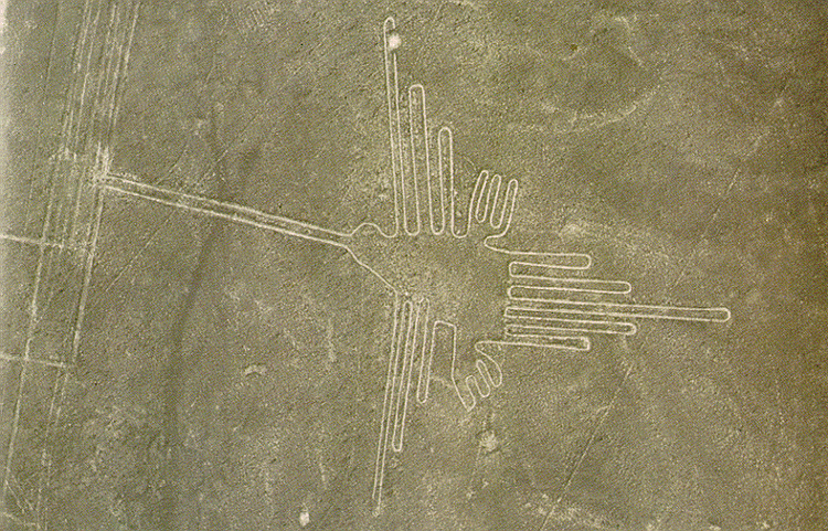
"...I am most interested in how the ancient people solved the technical problem of producing these huge figure drawings in such perfect proportions, at the same time not being able to recognize their shape from the ground. Enlarging the image from a smaller model could have only done this. But the model could not have been too small! For instance, it would take the figure of the monkey (18 meters in diameter), the toes having a length of less then 2 meters. In order to have every detail of the figure appear on the chart in its proper size and direction, proportion, and position, within the figures in a way that could have been enlarged, the chart must have been at least the length of 2 meters. The only material for such a chart is cloth.

In excavations at the foot of the plains people have found huge bolts of plain cloth without drawings. I have often found small pieces of red and white chalk on the pampa which did not belong to the area, but which could have been used to make drawings on the cloth. We know that these people not only wove their patterns on cloth, but also drew, and painted them. ..."

Printer Friendly | Permalink |  | Top
 
DU AdBot (1000+ posts) Click to send private message to this author Click to view 
this author's profile Click to add 
this author to your buddy list Click to add 
this author to your Ignore list Thu Apr 25th 2024, 06:29 AM
Response to Original message
Advertisements [?]
 Top

Home » Discuss » The DU Lounge Donate to DU

Powered by DCForum+ Version 1.1 Copyright 1997-2002 DCScripts.com
Software has been extensively modified by the DU administrators


Important Notices: By participating on this discussion board, visitors agree to abide by the rules outlined on our Rules page. Messages posted on the Democratic Underground Discussion Forums are the opinions of the individuals who post them, and do not necessarily represent the opinions of Democratic Underground, LLC.

Home  |  Discussion Forums  |  Journals |  Store  |  Donate

About DU  |  Contact Us  |  Privacy Policy

Got a message for Democratic Underground? Click here to send us a message.

© 2001 - 2011 Democratic Underground, LLC