n2doc
n2doc's Journal


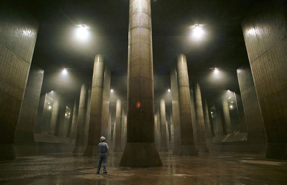
G-Cans, The World's Largest Drain
By Atlas Obscura
The G-Cans project, more officially known as the Metropolitan Area Outer Underground Discharge Channel, is a massive underground waterway and water storage area built to protect Tokyo from flooding during monsoons.
G-Cans opened in 2009 after 27 years of construction. With its 59 pillars, miles of tunnels, and 83-foot ceilings, the vast space resembles an underground temple. Five 21-story concrete silos collect rainwater, preventing overflow of the city's rivers and waterways. The humongous drainage system can pump over 12,000 tons of water per minute--the equivalent of four-and-a-half Olympic swimming pools.
There are daily free tours of the drainage system, but you are required to bring your own translator if you can’t understand Japanese. This precaution ensures that, in the event of an emergency, you will be able to follow evacuation instructions.
More photos of G-Cans can be seen on Atlas Obscura.
http://www.slate.com/blogs/atlas_obscura/2013/05/17/g_gans_the_world_s_largest_drain_sits_below_saitama_japan.html
Satellite Shoots Beautiful 6,000-Mile-Long Panoramic Photo from Orbit
Eric Calouro · May 19, 2013
 ?resize=620%2C574
There’s a slew of super-large panorama pictures available on the web, but when was the last time you heard about a picture that spans well over half the diameter of Earth?
That’s exactly what NASA’s Landsat Data Continuity Mission captured last month from a whopping 438 miles above the surface of our great blue marble. Measuring in at an impressive 6,000 miles in length and 120 miles wide, the panorama stretches from Northern South Africa to East Russia. NASA calls this work of art ‘The Long Swath’, and it comes in at 19.06 gigapixels.
Fifty-six still images make this strip of gorgeous Earth scenery possible, and given that Landsat is orbiting the planet at about 17,000 miles per hour, it took only — wait for it — twenty minutes to capture. That’s impressive. What’s more interesting, however, are the variations on Earth’s surface. Flourishing forests to barren deserts, lakes, and everything in between – and the colors are amazing.
So what makes this different than firing up Google Earth and viewing the whole world? With Google Earth, you’re looking at a bunch of different pictures shot at different times. The beauty here is that this one super-long picture was captured in one fell swoop.
It’s certainly worth a look, even if you don’t have time to explore the picture in its entirety.
You can view the full interactive version on Gigapan, watch the tour video, view the entire panorama in 15 minutes, or load it up on Google Earth.
Read more at http://petapixel.com/2013/05/19/satellite-shoots-beautiful-6000-mile-long-panoramic-photo-from-orbit/
Maxed Out on Everest
By Mark Jenkins

An hour above high camp on the Southeast Ridge of Everest, Panuru Sherpa and I passed the first body. The dead climber was on his side, as if napping in the snow, his head half covered by the hood of his parka, goose down blowing from holes torn in his insulated pants. Ten minutes later we stepped around another body, her torso shrouded in a Canadian flag, an abandoned oxygen bottle holding down the flapping fabric.
Trudging nose to butt up the ropes that had been fixed to the steep slope, Panuru and I were wedged between strangers above us and below us. The day before, at Camp III, our team had been part of a small group. But when we woke up this morning, we were stunned to see an endless line of climbers passing near our tents.
Now, bumper to bumper at 27,000 feet, we were forced to move at exactly the same speed as everyone else, regardless of strength or ability. In the swirling darkness before midnight, I gazed up at the string of lights, climbers’ headlamps, rising into the black sky. Above me were more than a hundred slow-moving climbers. In one rocky section at least 20 people were attached to a single ratty rope anchored by a single badly bent picket pounded into the ice. If the picket popped, the rope or carabiner would instantly snap from the weight of two dozen falling climbers, and they would all cartwheel down the face to their death.
Panuru, the lead Sherpa of our team, and I unclipped from the lines, swerved out into open ice, and began soloing—for experienced mountaineers, a safer option. Twenty minutes later, another corpse. Still attached to the line of ropes, he was sitting in the snow, frozen solid as stone, his face black, his eyes wide open.
more
http://ngm.nationalgeographic.com/2013/06/125-everest-maxed-out/jenkins-text
Ancient discovery set to rewrite Australian history
Five copper coins and a nearly 70-year-old map with an ‘‘X’’ might lead to a discovery that could rewrite Australia’s history.
Australian scientist Ian McIntosh, currently Professor of Anthropology at Indiana University in the US, plans an expedition in July that has stirred up the archaeological community.
The scientist wants to revisit the location where five coins were found in the Northern Territory in 1944 that have proven to be 1000 years old, opening up the possibility that seafarers from distant countries might have landed in Australia much earlier than what is currently believed.
Back in 1944 during World War II, after Japanese bombers had attacked Darwin two years earlier, the Wessel Islands - an uninhabited group of islands off Australia’s north coast - had become a strategic position to help protect the mainland.
Australian soldier Maurie Isenberg was stationed on one of the islands to man a radar station and spent his spare time fishing on the idyllic beaches.
While sitting in the sand with his fishing-rod, he discovered a handful of coins in the sand.
Read more: http://www.theage.com.au/national/ancient-discovery-set-to-rewrite-australian-history-20130519-2juck.html


Profile Information
Gender: Do not displayMember since: Tue Feb 10, 2004, 01:08 PM
Number of posts: 47,953