CFR Maps Let You Track Outbreaks Of Preventible Diseases, Anti-Vax Clusters
EDIT
"The refusal rates in the U.S. and Europe are highest among highly educated, wealthy parents, many of whom started to refuse vaccination 20 years ago," says Laurie Garrett, a senior fellow at the Council on Foreign Relations, which maintains the maps.
"The children that were never fully vaccinated are now of college age, and many of the outbreaks are focused around college campuses, where the unvaccinated carriers of pertussis, measles, and mumps are housed in dorms with the rest of the population, and spread the diseases."
So, while government vaccination programs have prevented outbreaks in, say, the eastside of Los Angeles, activist parents have turned back the clock in Mill Valley, California, and Vashon Island, near Seattle.
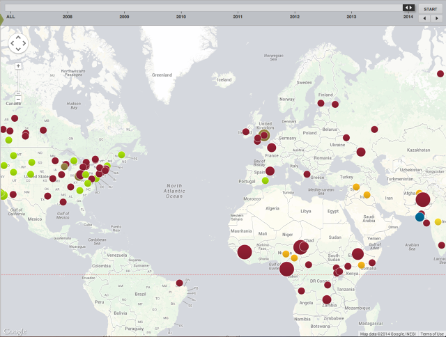
The CFR has been tracking outbreaks since 2008, and updates the maps weekly, Garrett says. Measles is in red, mumps is dark green, rubella is blue, polio is orange, and whooping cough is green. The yellow blobs are other diseases, like cholera and chicken pox.
EDIT
http://www.fastcoexist.com/3031524/visualized/these-maps-of-preventable-diseases-show-you-where-the-anti-vaxxers-are
 = new reply since forum marked as read

