NASA's 'GoreSat' Mission Just Released Its First Image of Earth
Source: Bloomberg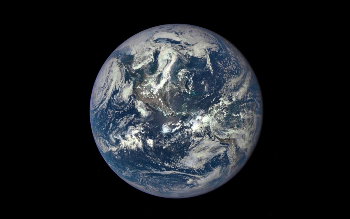
The first image of Earth released by NASA's Deep Space Climate Observatory, whose camera, a million miles away, will send home new photos every day.
NASA's 10-year, 3-billion-mile mission to Pluto electrified the world last week when it dispatched images of a tiny planet that's dynamic in ways even experts never anticipated. So while 3 billion miles is the current bar to ignite mission-mania in the public eye, a million-mile jaunt still isn't too shabby.
NASA has released the first image taken from the Deep Space Climate Observatory (DSCOVR), a collaboration with the National Oceanic and Atmospheric Administration (NOAA) that will study both the Sun and the Earth.
The satellite was launched in February. In early June it reached its new home, 1 million miles away. That faraway point, which astronomers refer to as L1, is a kind of gravitational balancing point between the Earth and the Sun. A satellite occupying that position remains more or less stationary relative to the two orbs.
DSCOVR will send back new images every day so that people around the world can see the whole planet in living color. The project was conceived by then-Vice President Al Gore in 1998, built within two years, and set aside. "GoreSat," as the Earth-camera became known informally, was reborn in 2008 as a sideshow to DSCOVR's main mission, which is to monitor the Sun's "weather" for NOAA and give earthlings a heads-up if electromagnetic storms are headed our way.
Read more: http://www.bloomberg.com/news/articles/2015-07-20/nasa-s-goresat-mission-just-released-its-first-image-of-earth
Congratulations to Al Gore, NASA, NOAA, and SpaceX!

 = new reply since forum marked as read
Highlight:
NoneDon't highlight anything
5 newestHighlight 5 most recent replies
= new reply since forum marked as read
Highlight:
NoneDon't highlight anything
5 newestHighlight 5 most recent replies

bananas
(27,509 posts)DSCOVR mission releases first EPIC global view of Earth, more to come in September
Posted By Emily Lakdawalla
20-07-2015 14:33 CDT
Five months after its launch, the Deep Space Climate Observatory (DSCOVR) mission has successfully journeyed to the region of space where Sun and Earth gravitational attraction offset each other. From the vantage point of L1, DSCOVR's EPIC camera has captured its first full-globe view of Earth, and it's well, epic.
There's something very moving about this photo -- its color is more muted than a lot of previous NASA "blue marble" pictures. From its point of view at L1, DSCOVR will always see a fully-lit Earth, rotating in place as the days pass, and pitching up and down with the shifting of seasons. I can't wait for more like this, of course, so I fired off a couple of emails asking for more details about how it was taken and what the plan for future data release is.
<snip>
One last thing I thought I'd mention about it is that you might have noticed that North America looks smaller than it does in the most familiar "blue marble" picture previously released by NASA. Here's that one:
The difference between the two is one of distance. DSCOVR, located 1.6 million kilometers from Earth, has a similar perspective as though it were sitting at infinity; the effective map projection is an orthographic one. MODIS, orbiting only 700 kilometers above Earth, sees much less of the globe at a time. The Blue Marble image is a vertical perspective projection at some higher altitude than 700 kilometers, though I don't know what the altitude of projection is. As a result of its closer viewpoint, points near the center of the globe are much closer to the viewer than points at the globe's edge, so features near the center bulge -- it's the same effect that tends to make your nose look big when you take a selfie. I like the new perspective better!

onehandle
(51,122 posts)On edit: I read my reply title and had to add this pic...
[img] [/img]
bananas
(27,509 posts)

ffr
(22,675 posts)The little blue marble in this vast sea of darkness.

madokie
(51,076 posts)we really ought to be taking better care of this one. After all it's well within our ability to do just that
bananas
(27,509 posts)A New Blue Marble
Scott Kelly
July 20, 2015 12:04 PM EDT
Ed. note: This is cross-posted on Medium.
No one on this planet had ever seen a whole picture of the Earth until 1972.
We knew we lived on it, and had a vast amount of useful information about its makeup, its processes, and its place in the solar system. At the time, some of the most insightful individuals had begun to understand that we, the people who live on Earth, actually had the ability to influence the processes taking place on our planet.
But it was hard for many people to grasp this concept. It seemed abstract, distant, hard to visualize.
Enter “Blue Marble”:
It was the first full photo of the Earth, taken on December 7, 1972, by the American crew of the Apollo 17 spacecraft. The original Blue Marble is thought by many to be the most-reproduced image of all time.
<snip>
The DSCOVR mission serves several important purposes, including providing scientific data on heat and radiation fluxes across the Earth’s atmosphere, and maintaining the nation’s ability to provide timely alerts and forecasts for space weather events, which can disrupt telecommunications capabilities, power grids, GPS applications, and other systems vital to our daily lives and national and local economies.
And with its Earth Polychromatic Imaging Camera (which has an epic acronym. Seriously. It’s EPIC), DSCOVR will capture and transmit full images of the Earth every few hours! The information gathered by EPIC will help us examine a range of Earth properties, such as ozone and aerosol levels, cloud coverage, and vegetation density, supporting a number of climate science applications.
One of the best parts of this mission is that NASA will make all of the data, data products, and images collected by DSCOVR freely available to the public, including the new “Blue Marble” images. Later this year, you’ll be able to view and download new “Blue Marble” images taken by DSCOVR every day.
In addition to providing useful data to scientists and researchers, these images will remind all of us that we live on a planet, in a solar system, in a universe. And that we are not just Americans, but citizens of Earth.
Scott Kelly is a NASA astronaut, currently spending a year on the International Space Station.
LuckyLib
(6,821 posts)entity between the people and seeing the planet they live on.
Uncle Joe
(58,481 posts)
Thanks for the thread, bananas.


delrem
(9,688 posts)Triana
(22,666 posts)Deep Space Climate Observatory (DSCOVR) (formerly known as Triana, unofficially known as GoreSat) is a NOAA Earth observation and space weather satellite launched by SpaceX on a Falcon 9 launch vehicle on 11 February 2015 from Cape Canaveral.
It was originally developed as a NASA satellite proposed in 1998 by then-Vice President Al Gore for the purpose of Earth observation. It is intended to be positioned at the Sun-Earth L1 Lagrangian point, 1,500,000 km (930,000 mi) from Earth, to monitor variable solar wind condition, provide early warning of approaching coronal mass ejections and observe phenomena on Earth including changes in ozone, aerosols, dust and volcanic ash, cloud height, vegetation cover and climate. At this location it will have a continuous view of the Sun and the sunlit side of the Earth. The satellite is planned to orbit the Sun-Earth L1 point in a six-month period, with a spacecraft-Earth-Sun angle varying from 4 to 15 degrees. It will take full-Earth pictures about every two hours and be able to process them faster than other Earth observation satellites.
DSCOVR has an expected arrival at L1 around the beginning of June 2015.
Originally known as Triana, named after Rodrigo de Triana, the first of Columbus's crew to sight land in the Americas, the satellite's original purpose was to provide a near-continuous view of the entire Earth and make that live image available via the Internet. Gore hoped not only to advance science with these images, but also to raise awareness of the Earth itself, updating the influential Blue Marble photograph taken by Apollo 17. In addition to an imaging camera, a radiometer would take the first direct measurements of how much sunlight is reflected and emitted from the whole Earth (albedo). This data could constitute a barometer for the process of global warming. The scientific goals expanded to measure the amount of solar energy reaching Earth, cloud patterns, weather systems, monitor the health of Earth's vegetation, and track the amount of UV light reaching the surface through the ozone layer.
In 1999, NASA's Inspector General reported that "the basic concept of the Triana mission was not peer reviewed", and "Triana's added science may not represent the best expenditure of NASA's limited science funding." The Bush Administration put the project on hold shortly after George W. Bush's inauguration. Congress asked the National Academy of Sciences whether the project was worthwhile. The resulting report stated that the mission was "strong and scientifically vital."
Triana was removed from its original launch opportunity on STS-107 (the ill-fated Columbia mission in 2003). The $100 million satellite remained in storage for the duration of the Bush administration. In November 2008 the satellite was removed from storage and began recertification for a possible launch on board a Delta II or a Falcon 9. Al Gore used part of his book Our Choice (2009) as an attempt to revive debate on the DSCOVR payload. The book mentions legislative efforts by Senators Barbara Mikulski and Bill Nelson to get the satellite launched. NASA renamed the satellite Deep Space Climate Observatory (DSCOVR), in an attempt to regain support for the project. In February 2011, the Obama administration attempted to secure funding to re-purpose the DSCOVR spacecraft as a solar observatory to replace the aging Advanced Composition Explorer (ACE) spacecraft.
In September 2013 NASA cleared DSCOVR to proceed to the implementation phase targeting an early 2015 launch, which had been announced in December 2012 as launching on a SpaceX Falcon 9 rocket. NASA Goddard Space Flight Center is providing management and systems engineering to the mission.
http://en.wikipedia.org/wiki/Deep_Space_Climate_Observatory
bananas
(27,509 posts)And I enjoy your posts immensely!
Keep posting!
Spitfire of ATJ
(32,723 posts)
Besides, this one is matching Earth's orbit around the sun keeping a full disk in daytime.

Marty McGraw
(1,024 posts)oily Correxit sheen I see in the gulf? What's with the turquoise color?

kentauros
(29,414 posts)and covers the Pacific side of Central America and part of the Gulf. That's the sheen you're seeing. The turquoise colored areas are shallow seas around islands, such as the Caribbean and Cuba 
Take a look on Google Earth and you'll see the same thing.
Marty McGraw
(1,024 posts)
bananas
(27,509 posts)

Sunlei
(22,651 posts)in science we can thank the big O for?
one thing is where's the green? there always used to be some greenish color land in places like the amazon.
bananas
(27,509 posts)<snip>
The images are being taken with the Earth Polychromatic Imaging Camera (EPIC), which has a detector 2048 by 2048 pixels square. Here is a fact sheet about EPIC(PDF). EPIC has a monochromatic detector and a filter wheel with 10 very narrowband filters from ultraviolet to near-infrared wavelengths, 317 to 779 nanometers. For more information about the image released today, Cole put me in touch with DSCOVR project scientist Adam Szabo.
<snip>
Because the filters are so narrowband, a straight combination of red, green, and blue filter images wouldn't make a photo with as much verisimilitude as the one released today. I asked Szabo about that, and he told me:
Standard RGB jpeg images are encoded as three numbers, one for red, one for green and one for blue. We have three numbers on DSCOVR. The question is how to scale the three relative to each other. We have adjusted the exposure times to make sure that we are neither saturated nor lost in low signal to noise values. Then we followed the human eye color response spectrum. The human eye is much more sensitive to red and green than blue colors. But the EPIC instrument is equally sensitive to all of the filter settings. So, before combining the three filtered images, we have reduced the contribution of blue and slightly changed red. This is our best guess as how a human observer would see the Earth from L1.
The popular MODIS Earth images are enhanced in color to bring out surface features. Also, they have removed the effect of light scattered by atmospheric molecules. We will do the same for the regular processing and distribute both the human eye response coloring and the enhanced images.
The first light images are all human eye response colors.
<snip>

Fred Sanders
(23,946 posts)Last edited Tue Jul 21, 2015, 02:13 PM - Edit history (2)
Delphinus
(11,845 posts) 
bucolic_frolic
(43,420 posts)OMG don't tell the Rethuglicans. It will be as big another BIRTHER issue.
LastLiberal in PalmSprings
(12,601 posts)For all you screen saver fans:
XXX.nesdis.noaa.gov/DSCOVR/images/187_1003705_americas_dxm.png
Replace XXX with www and click on the magnifying glass cursor icon on the resulting image.
bucolic_frolic
(43,420 posts)You know who said it!  )))
)))

tclambert
(11,087 posts)NASA always blacks out the giant turtle. That's why there are no stars visible in this supposed image of space. Which proves the existence of the giant turtle. QED

ThoughtCriminal
(14,050 posts)Simply because Al Gore backed it. They completely ignored all of the scientific benefits to ridicule it as "Al Gore's Screensaver". But, they aren't scientists are they?
wildbilln864
(13,382 posts)
daleo
(21,317 posts)But definitely awesome.