General Discussion
Related: Editorials & Other Articles, Issue Forums, Alliance Forums, Region ForumsSpeculation from Italy: Capt. Sailed Costa Concordia Thru Dangerous Strait off Island Coast
<snip>
Antonio Belardo, a local official, said the ship deviated from its “usual” route in order to give passengers a view of Giglio’s port. That meant navigating a strait, so that the ship could skirt a stretch of the small island’s coastline that faces mainland Italy.
Gianni Onorato, managing director of Carnival Corp.’s Costa Cruises, which operated the ship, told reporters on Saturday that the course taken by the ship Friday evening was “not a defined route for passing Giglio.” However, Mr. Onorato said it would be “incorrect to say the ship was off course,” adding that he was unaware of all of the possible routes available to the captain at the time.
“It’s difficult to say at this moment what happened,” Mr. Onorato said, adding that the company was cooperating with authorities to “shed light on the causes of this tragedy that is unprecedented in our 64-year history.”
Italian media reported that the boat hit a grouping of rocks known as Le Scole, located about one kilometer, or a half-mile, off the coast of Giglio.
</snip>
This seems to be supported by the AIS tracking of the ship:
 = new reply since forum marked as read
Highlight:
NoneDon't highlight anything
5 newestHighlight 5 most recent replies
= new reply since forum marked as read
Highlight:
NoneDon't highlight anything
5 newestHighlight 5 most recent replies

Rhiannon12866
(205,289 posts)Having seen the proximity of this very large ship to the shore, an accident seems unavoidable. Perhaps the captain was used to a much smaller ship. What a terrifying experience for all involved... 

Cooley Hurd
(26,877 posts)...swung around 180 degrees with her prow ultimately facing south. Regardless, that's an awfully large ship - with 4000(!) passengers' lives at stake - to attempt anything even remotely that dangerous.
Marnie
(844 posts)the end of the gash in the ships hull.
Any crew working in that part of the ship are presumably dead and possibly crushed to a pulp.

muriel_volestrangler
(101,311 posts)there's a button for Google translate on the right - a British flag - which gives:
The newsletter ElbaReport indicates that long-standing practice was during Costa's cruises offer passengers a panoramic tour of the Lily browsing a few hundred meters from the coast of the island. Move up in the cache site Giglionews - unreachable until Saturday evening because of excessive traffic - not only can you find a letter of thanks from the mayor Ortelli to the skipper, but he also learns that August 14, 2011 the ship had carried out a flyby in front of the island at 22:00:
(Giglio = Lily in translation)
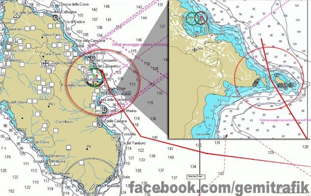
That chart seems to show Le Scole may be a kilometre from the port, but scarcely a hundred yards from the nearest point on the island. Incredible they would try to sail that close to land without complete control of the ship and precise knowledge of their position (and the captain on the bridge).
Cooley Hurd
(26,877 posts)...yet they pulled it off back in August. Perhaps they thought their luck would hold out?
muriel_volestrangler
(101,311 posts)with a 950 foot ship. I think the idea would be to approach the port in the dark anyway, so that the lights are pretty; but to do it in the deeper water (once you're outside Le Scole, the bottom is a lot deeper - I'd guess that Mediterranean chart is in metres, so there's 50 metres available just a couple of hundred metres off the coast. But they should have turned a lot sooner than the turn near what seems to read 'Toricella'.
Cooley Hurd
(26,877 posts)My first thought was the Honda Point disaster of 1923, but that happened in dense fog. By all accounts, it was clear off Giglio on Friday night. I have to wonder if they lost power first, while in the midst of a close pass to Giglio Harbor, and then lost control, slamming into the rocks in the strait, making it though it but then swinging 180 degrees against the jutting rock north of the harbor and coming to rest.


malaise
(268,968 posts)You clearly are an expert on the subject
Cooley Hurd
(26,877 posts)
muriel_volestrangler
(101,311 posts)In Italian, and the voiceover translation may make it difficult for any Italian speakers here to say whether the translation is any good or not - it doesn't make much sense to me, but here's what they give:
"Even though we were sailing along the coast with the tourist navigation system, I firmly believe that the rocks were not detected as the ship was not heading forward but sideways as if underwater there was this rock projection.
"I don't know if it was detected or not but on the nautical chart it was marked just as water at some 100-150 meters from the rocks and we were about 300 meters from the shore, more or less.
"We shouldn't have had this contact."
http://news.sky.com/home/world-news/article/16149523
300 metres from shore clearly doesn't agree with the course shown on the chart in the OP. We'll see what the black box says.
Cooley Hurd
(26,877 posts)Shouldn't the helmsman be steering the ship and not a tourist? 

My guess is - bad translation.
muriel_volestrangler
(101,311 posts)at least once: http://www.bbc.co.uk/news/world-europe-16568037
riderinthestorm
(23,272 posts)failed. Do you think this is what may have happened? I too appreciate your posts on this....
http://sync.democraticunderground.com/1002169013
muriel_volestrangler
(101,311 posts)on the http://gcaptain.com/cruise-ship-costa-concordia-sinks/?37456 page. marinetraffic.com shows the ship keeping a relatively safe distance off the island; the Gemitrafik one (which is also in this OP) shows it getting so close it passes inshore of a rock. Clearly at least one of them is wrong; perhaps the best thing to do is not trust either of them, but wait for the official investigation.
riderinthestorm
(23,272 posts)Of course that may also be some spin....
There's a lot going on here. For now, I keep hoping they find the rest of the people who are missing and they are alive.

TeeYiYi
(8,028 posts)According to people left stranded on the ship, the captain was seen escaping in a lifeboat, hidden under a blanket. I think it was around 11:30... an hour or so after the ship first ran aground.
They were still trying to evacuate people at 3 am, almost 4 hours after the captain fled to safety. The coast guard tried to talk the captain into going back to his ship but he ignored their pleas.
He's a coward and most likely a lying coward. He deserves whatever he gets as far as being prosecuted for this terrible tragedy.
TYY
riderinthestorm
(23,272 posts)
ahimsa
(426 posts)If this is the same place as on the map in the OP:
http://g.co/maps/jmejd (google map link)
It looks like it's no more than 200 feet wide.
muriel_volestrangler
(101,311 posts)I reckon. But if they had enough control to pilot it through that small gap (rather than straight into a rock above sea level), you'd think they had enough control to stop, or go outside the rock, instead.

BiggJawn
(23,051 posts)"Hey, y'all, watch THIS..."