General Discussion
Related: Editorials & Other Articles, Issue Forums, Alliance Forums, Region ForumsHoly Shit - they're saying Cat3 Hurricane Michael - and it's now Cat4 with 140mph winds
Last edited Wed Oct 10, 2018, 05:13 AM - Edit history (1)
This is getting serious
 = new reply since forum marked as read
Highlight:
NoneDon't highlight anything
5 newestHighlight 5 most recent replies
= new reply since forum marked as read
Highlight:
NoneDon't highlight anything
5 newestHighlight 5 most recent replies

Achilleaze
(15,543 posts)

TheBlackAdder
(28,169 posts)

malaise
(268,724 posts)
TheBlackAdder
(28,169 posts)malaise
(268,724 posts)but we both know there are folks who think that way 

NewsCenter28
(1,835 posts)In his deadlocked senate race. I’m praying it is nowhere near as bad as feared.
Achilleaze
(15,543 posts)
Awsi Dooger
(14,565 posts)Rick Scott was wearing a NAVY hat and matter of factly telling anyone in the panhandle how to proceed. He was terrible at this type of thing early in his years as governor but now he has a relaxed effective delivery with proper emphasis, and it fools many people into believing he gives a damn
malaise
(268,724 posts)Another major hurricane approaches

Lars39
(26,107 posts)Where are you seeing Cat3?
Are you translating wind speeds?

Ilsa
(61,690 posts)It wasn't supposed to be a hurricane until much later today. They revised the estimate from high Cat 2 to Cat 3.

BumRushDaShow
(128,527 posts)before it gets to Florida so it will probably explode. Things to look out for at this point though is how it interacts with land (cone is showing it side-swiping Cuba) and what that does to the circulation... as well as what kind of wind shear (if any) happens once it is in the Gulf.
Lars39
(26,107 posts)We’re leaning hard on cancelling our vacation to Top Sail Preserve State Park.
BumRushDaShow
(128,527 posts)
My concern is how much rain this could generate once it gets on land because rivers are still running high in the Carolinas and this will just exasperate it.

dixiegrrrrl
(60,010 posts)
Lars39
(26,107 posts)That is one of the places the sea turtles go to hatch their eggs. 
dixiegrrrrl
(60,010 posts)I have been gratified to see stories of beach volunteers who rescue the exposed eggs, and hatchlings, after storms.
Lars39
(26,107 posts)I thought it was in the summer. The dunes there are beautiful.

aikoaiko
(34,163 posts)Most are hatched by now but a few late nests might still be there.

Separation
(1,975 posts)If so, that was my wife and I's favorite place to go while I was in the Marine Corps and stationed there. There was a little restaurant that had a pier that went over the water and we would go there every weekend for the French Onion soup. Then hurricane Bertha came through and totally destroyed it. Nobody was allowed to rebuild there after that storm.
Lars39
(26,107 posts)Sounds like a good memory though. 

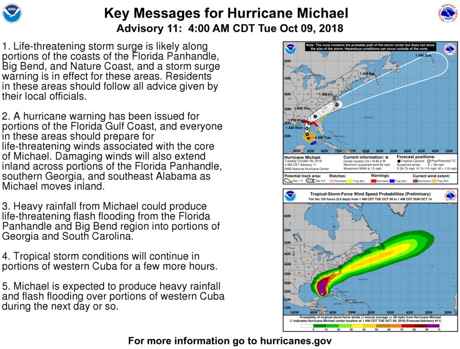
YessirAtsaFact
(2,064 posts)Michael will become a major hurricane by Tuesday night.
Sustained winds of 110 mph or more.
malaise
(268,724 posts)https://www.washingtonpost.com/weather/2018/10/08/michael-strengthens-hurricane-is-forecast-make-landfall-florida-dangerous-category-midweek/?noredirect=on&utm_term=.e44637619768
Capital Weather Gang
Michael strengthens to a hurricane and is forecast to make landfall in Florida as a ‘dangerous’ Category 3 midweek
Hurricane Michael is strengthening as it enters the Gulf of Mexico, and Florida is its target. The storm is expected to become a major Category 3 hurricane by the time it reaches the northern Gulf Coast on Wednesday. It will probably be the area’s strongest hurricane in 13 years.
“Michael is forecast to be a dangerous major hurricane when it reaches the northeastern Gulf Coast on Wednesday, and life-threatening storm surge is possible along portions of the Florida Gulf Coast,” the National Hurricane Center wrote Monday.
The storm surge, which is the rise of ocean water at the coast above normally dry land, could reach at least 8 to 12 feet, inundating roads, homes and businesses at the coast.
In addition, “heavy rainfall from Michael could produce life-threatening flash flooding from the Florida Panhandle and Big Bend region into portions of the Carolinas through Thursday,” the Hurricane Center warned.
Looks like we *were* going to Top Sail Preserve State Park this weekend.

csziggy
(34,131 posts)We're outside of Tallahassee but are supposed to board a ship in Tampa on Thursday. Originally we were driving down Wednesday but we're leaving tomorrow ahead of the winds. We'll still have wind and rain but will be inland and should not get into any serious bands.
Our major worry is gas - lots of lines and some stations are running out. My husband was supposed to fill up last Friday but didn't. He's headed to Costco right now to try to fill his car for the drive down.
Save your trip to the sugar sands of the Panhandle or a few weeks.
Lars39
(26,107 posts)I really appreciate the added insight, csziggy.
dixiegrrrrl
(60,010 posts)It stems from 1995 ( when I was still single) Hurricane Opal was supposed to just graze our area, but in the middle of the night she turned.
The water was ankle deep when I woke up and fled my lil house in the woods, luckily I had enough gas to get out of the area.
I learned the definition of Straight line winds when I returned 3 days later to see 4 trees had dropped on that house.
Never ever take hurricane forecasts for granted.
csziggy
(34,131 posts)When he headed home LAST week!
At least he didn't have much problem filling it today. Costco had lines but plenty of gas.

DrDan
(20,411 posts)Lars39
(26,107 posts)DrDan
(20,411 posts)……………………..Wind km/hr...….Pressure (mb)
Category 5...…….>250...……………<920
Category 4......210-250...………..920-944
Category 3......179-210......…...945-964
Category 2......155-178......…...965-979
Category 1......120-155...………….? 980
Mike, from Mike's Weather Page yesterday used this scale with the projected barometric pressure of 950 mb and predicted a cat-3.
Take a look at his page on facebook. He goes live twice a day on facebook during hurricane season. I like him because he is not linked to a single model but discusses all of them.
Lars39
(26,107 posts)dixiegrrrrl
(60,010 posts)this is the scale as we have come to know it down here in hurricane country:

I got this from Wiki, same scale is on the NOAA site:
https://www.nhc.noaa.gov/aboutsshws.php
csziggy
(34,131 posts)We're used to seeing it in miles per hour. I had to look twice to realize the difference.
DrDan
(20,411 posts)
royable
(1,263 posts)malaise
(268,724 posts)Last edited Fri Oct 12, 2018, 06:09 PM - Edit history (1)
I accept that the Cat4 was overnight but we were discussing Cat3 since Monday and you did mention Cat4 from a reference.
DrDan
(20,411 posts)for downplaying it - particularly the media in the Panama City area.. They were speaking of "tropical conditions". I heard him blasting them for being irresponsible in storm reporting - telling folks not to worry - it's not a big deal.
And what do we get - a strong strong cat 4. 3rd worst storm ever. Worst to ever hit Florida gulf.
Mike pays infinitely more attention to the details than our weather folks do.
Gonna get me one of his drunk-donkey t-shirts in support of his reporting.
I'd like to see him on Anderson Cooper
Baclava
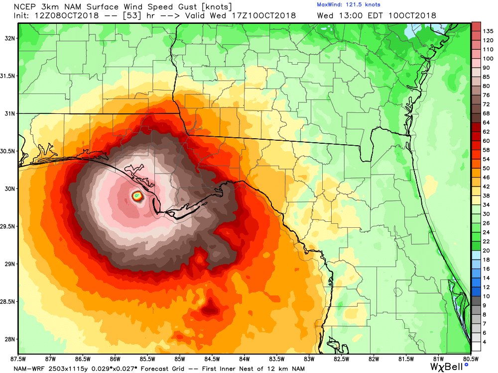
(12,047 posts)Right now still looking like east of Panama City towards Apalachicola


spanone
(135,795 posts)
Grammy23
(5,810 posts)With my niece and her husband and will fly to France from Boston tomorrow. Did very little prep before we left due to running out of time and this storm was a bit of a surprise to build up so quickly. We are on the edge of the cone so unless something really weird happens, we should be fine. I have had to talk my husband down from the trees as he has worried incessantly since no storm path is certain until it makes landfall. I reminded him if we were home, we would do just a few more things like take down our bird feeders and buy a few things for our hurricane stash. As it is, we will be getting on a River Cruise and will be looking at the storm from 4500 miles away.
I hope Michael is not as bad as they suggest he may be and surely hope that the Carolinas get a break on the rain. Saw Rick Scott this a.m. trying to look prepared, etc. I hope he goes down in flames on Election Day!
Be safe to all those in the path of the storm! Heed the warnings!

Phoenix61
(16,994 posts)Please post about it when you return. I'm concerned about the storm. Cat 2's are just a big, fat pain in the tush. Cat 3's make me nervous. I'm planning on heading to a friend's house 40 miles inland.
Hortensis
(58,785 posts)from deck chairs and dining tables on one of the great rivers of Europe sounds about as different from a hurricane as you can get. Water the only common denominator. Have to remember that next time we need to flee a hurricane.
Have a lovely time.

The Blue Flower
(5,434 posts)The grocery stores are packed. By the time I was ready to get gas an hour later, the lines to the gas stations were out to the streets (Tallahassee). I figure people are doing it today because they're off work for Columbus Day. We still have until tomorrow night.
malaise
(268,724 posts)Batten down. 
csziggy
(34,131 posts)In Pensacola! That's nuts!
My husband had to go to Publix to pick up stuff for our cruise - there were no carts at all in the parking lot or in the front of the store.
And we were just worried about using up stuff in the fridge before we leave for our trip.
Hortensis
(58,785 posts)have warned us that unprepared folk in the mass evacuations heading north from south Florida tend to start running out of gas around Ocala-Gainesville. They thought we should know we needed to prep ahead even though expecting to stay comfortably at home.
That direction's not your concern this time, of course. Hope all goes well and you have a very ice time.
csziggy
(34,131 posts)Filled up with gas south of Gainesville. No lines but every pump space taken. Traffic wasn't too bad. Only bad rain was right where the turnpike left I-75 - absolutely opaque down pour for just those few miles.
Now the Weather Channel is saying Cat 4! If no power at home we can stay down here after the cruise. Mom's house is being tented this weekend but we could stay there once they clear it. I hope our old cat will be okay. Last storm he stayed cuddled up with me. He has a cat door so can get inside but will be alone.
Hortensis
(58,785 posts)knowing boarding them out would be a serious trauma in itself. Little danger from the hurricane itself, at least. He'll be snug inside and have too much sense to go out.
Saw the tide is especially high in Tampa. Wonderful. We have an old MH on the water there, so it'll be up over the old sea wall already. Sigh.
Imagine you'll be heading for your ship. Hope the food's great.

Scurrilous
(38,687 posts)
BumRushDaShow
(128,527 posts)This is a cool site posted here alot - https://earth.nullschool.net/#current/wind/surface/level/orthographic=-86.19,21.06,1106
All kinds of things spinning out in the oceans. 
dixiegrrrrl
(60,010 posts)Those lovely wind graphics explain it all.
and when I spun the globe, 2 cyclones ...or typhoons??...on either side of India, and one between Hawaii and Wes Coast.
BumRushDaShow
(128,527 posts)and coupled with one out in the Atlantic, just west of where TS Leslie is spinning, they are shunting an easterly flow (due to their clockwise circulation) into the east coast. We have been socked in with fog/mist/low stratus clouds all day here in Philly, due to the easterly flow off the ocean.
And yup, good ole Mother Earth is continually spinning up storms all over the place to try to bring the atmosphere into equilibrium - 24/7/365.

Tree-Hugger
(3,370 posts)And fellow weather enthusiast?
I'm a Summer-lovin' gal, but I am thoroughly over the humidity this year.
BumRushDaShow
(128,527 posts)
(which will be almost 49 years in a few months
)
Between here and a garden forum, I also post on a weather forum.
Tree-Hugger
(3,370 posts)I have been obsessed with weather since I was a little kid. I'm just a few years younger than you.
I keep forgetting DU has a weather forum.
You're probably already on it, but there is a great local site called PhillyWx that rocks.
BumRushDaShow
(128,527 posts)
Looks like it started around 2012. Ha! No I haven't been in there. I post on American Weather forum, a/k/a AmericanWx (used to be called Eastern Weather a/k/a EasternWx). I remember when a bunch of folks left the Philly Region subforum and setup PhillyWx (including a number of the Mt. Holly mets). I do go over there every once in awhile but at this point I am doing too many forums and trying to do chores too so it's getting out of hand!
I also post on gardenweb too and I have seen a bunch of longtime posters there who are longtime posters here on DU.Scurrilous
(38,687 posts)
BumRushDaShow
(128,527 posts)Looks like some of the convection over western Cuba is probably coming from Michael.

Blue_true
(31,261 posts)malaise
(268,724 posts)Please
Blue_true
(31,261 posts)The tracking map that you posted shows the south-western tip of Marion County getting some high wind. I live in the north-east section near eastern Alachua County. Marion County is one of the biggest counties in the state in terms of landmass, so I sit well out of the rough stuff. We did get some rain a few minutes ago, but no wind.
malaise
(268,724 posts) minoan
(95 posts)Looks like the coastal areas are going to be hit hard. We will get 65-75 mph sustained winds and a lot of rain as things stand now. We are all battened down for the duration. Got chocolate cake....
I was supposed to see Mayor Gillum in The Villages on Saturday but I'm expecting he'll cancel.
Hi mcar - Long time lurker with a few posts some years back. Just wondering if you live in The Villages. If so, tell me what it is like being a Dem there. Am considering a move there from Treasure Island in Florida. Edumacate me . . . .
malaise
(268,724 posts)but it will be bad - storm surge. Stay safe
mcar
(42,278 posts)As it brings it closer to me.
We're on TS watch right now.
Hubby called and said school has been cancelled in the district Tues and Wed as they are needed as shelters for those on the West coast. We live about 25 miles inland.
malaise
(268,724 posts)That's not bad news
Stay safe.
mcar
(42,278 posts) Blue_true
(31,261 posts)Stay safe.
mcar
(42,278 posts)Cetacea
(7,367 posts)A three doesn't surprise me and its fortunate its a fast mover.
malaise
(268,724 posts)so the rain part won't sit there for days or hours
That's good news

flying-skeleton
(696 posts)Dear Republican Voters:
Don't worry.
FL Governor just released a statement:
CLIMATE CHANGE IS A HOAX.
So see. Nothing to worry right?
Just like Trump said !!
So stay out of take a walk in the park or on the beach & enjoy the view and fresh air.
malaise
(268,724 posts)They should follow your advice.
Tree-Hugger
(3,370 posts)It's a great site with dozens of active models so you can track storms. He provides up to date reconnaissance information.
Levi also does a nightly video update whenever there is an active Tropical Storm or Hurricane impacting the U.S. He is extremely knowledgeable and very calm and thorough in his presentations.
malaise
(268,724 posts)Storm surge will be serious but the faster this moves (and it's now moving at 12mph) the better. That will limit the flooding.
And that's really good news.
Scurrilous
(38,687 posts)
workinclasszero
(28,270 posts)Thanks for the link
BumRushDaShow
(128,527 posts)
It doesn't really have much if any of an eye, although it is trying to form it. Probably got disrupted over western Cuba.
malaise
(268,724 posts)and it looks like Michael is heading for Atlanta as a tropical storm
BumRushDaShow
(128,527 posts)But once that happens, it will be off to the races.
Latest advisory just in (summary of it) has it now at 100 mph -
000
WTNT34 KNHC 091147
TCPAT4
BULLETIN
Hurricane Michael Intermediate Advisory Number 11A
NWS National Hurricane Center Miami FL AL142018
700 AM CDT Tue Oct 09 2018
...MICHAEL STRENGTHENING WHILE MOVING NORTH-NORTHWESTWARD OVER THE
SOUTHEASTERN GULF OF MEXICO...
...LIFE-THREATENING STORM SURGE...HURRICANE FORCE WINDS...AND HEAVY
RAINFALL EXPECTED ALONG THE NORTHEASTERN GULF COAST...
SUMMARY OF 700 AM CDT...1200 UTC...INFORMATION
----------------------------------------------
LOCATION...24.5N 86.1W
ABOUT 395 MI...635 KM S OF PANAMA CITY FLORIDA
ABOUT 365 MI...590 KM S OF APALACHICOLA FLORIDA
MAXIMUM SUSTAINED WINDS...100 MPH...155 KM/H
PRESENT MOVEMENT...NNW OR 345 DEGREES AT 12 MPH...19 KM/H
MINIMUM CENTRAL PRESSURE...968 MB...28.58 INCHES
https://www.nhc.noaa.gov/text/refresh/MIATCPAT4+shtml/090857.shtml?
The 8 am ET track is similar to the below -
Link to tweet
TEXT
National Hurricane Center
✔
@NHC_Atlantic
Hurricane Michael is moving north-northwestward over the Gulf of Mexico. Here are the 4 am CDT October 9th Key Messages on Hurricane #Michael.
5:24 AM - Oct 9, 2018
Link to tweet
TEXT
NHC director Ken Graham will provide a Facebook Live broadcast at 8:15 a.m. EDT (7:15 a.m. CDT) regarding Hurricane #Michael http://www.facebook.com/NWSNHC @NOAA @NWS @NWSWPC #HurricanePrep
7:47 AM - Oct 9, 2018
Baclava
(12,047 posts)
BumRushDaShow
(128,527 posts)Also the NHC Storm Surge folks just tweeted this out about 20 minutes ago -
Link to tweet
TEXT
NHC_Surge
✔
@NHC_Surge
Water levels will rise well in advance of the arrival of #Michael. It's essential that residents within the storm surge warning area finish preparations to protect life and property today.
9:17 AM - Oct 9, 2018
Because there is a new moon, the tides are already enhanced.
Bigger than Florence
malaise
(268,724 posts)The big difference here is that Florence stalled and flooded the Carolinas
This will be storm surge, wind and rain, but, at 12mph flooding from rain won't be a major problem.

sarcasmo
(23,968 posts)malaise
(268,724 posts) Scurrilous
(38,687 posts)
malaise
(268,724 posts)Not good news for Tallahassee
Scurrilous
(38,687 posts)Everything is shutting down for the rest of the week. Time to GTFO.
malaise
(268,724 posts)This is serious

JCMach1
(27,553 posts)malaise
(268,724 posts)Hope I'm right
malaise
(268,724 posts)
JCMach1
(27,553 posts)NG
Scurrilous
(38,687 posts)<snip>

Panama City Beach
"Hurricane Michael is expected to make landfall Wednesday in the Florida Panhandle as a Category 3 storm and is very likely to cause erosion at the base of sand dunes of three-quarters of the beaches along the panhandle and flood more than a quarter of its dunes, causing flooding behind protective dune lines, according to the U.S. Geological Survey.
If Michael continues to intensify and stay on the National Hurricane Center's forecasted path, storm surge impacts east of the hurricane's eye are expected to be most severe, where storm surge and waves could bring water levels to rise as high as 16 to 20 feet, the USGS predicts.
In the open Gulf of Mexico, wave heights are expected to hit as high as 40 feet, said Kara Doran, the research oceanographer for the USGS. Doran leads the agency's Coastal Change Hazards Storm Team in St. Petersburg, Florida.
“As the storm approaches the coast, the shallow seabed will reduce that wave height,” said Dorn. “But water levels in some parts of the Northeast Florida coast will still be high enough to overwhelm the dunes, which are relatively low and narrow.”
https://weather.com/news/news/2018-10-09-michael-storm-surge-erode-florida-beaches
malaise
(268,724 posts)and the wind will be stronger at the higher levels.
malaise
(268,724 posts)Don the Con is bad luck
<snip>
"The National Hurricane Center (NHC) says Hurricane Michael is packing even more punch: It strengthened into a Category 4 storm early Wednesday, with maximum sustained winds of 130 mph. According to the NHC's latest advisory, Michael could produce a life-threatening storm surge as high as 13 feet and dump as much as a foot of rain in some places.
Weather officials say Michael has been drawing energy from warm Gulf of Mexico waters, with ocean temperatures in the mid-80s.
The NHC said Michael should make landfall midday Wednesday in the Florida Panhandle or Florida "Big Bend" area. The storm is then forecast to weaken as it moves through the Southeastern United States.
States of emergency were in effect in Florida, Alabama and Georgia."
https://www.cbsnews.com/live-news/hurricane-michael-path-evacuation-florida-storm-surge-weather-forecast-today-2018-live-updates/
malaise
(268,724 posts)Get out of the way folks
LakeSuperiorView
(1,533 posts)Shouldn't the talebangelists be saying that gawd is punishing them?
malaise
(268,724 posts)And he's sure coming for them since the Con took office. This is the fifth major hurricane.

TexasTowelie
(111,977 posts)His memory can't recall what he said when Florence came through.a few weeks ago.
malaise
(268,724 posts)Not yet

wishstar
(5,268 posts)Also predicting 13 foot storm surge across cone area
Hortensis
(58,785 posts)malaise
(268,724 posts)Climate change anyone?
Hortensis
(58,785 posts)but at least that libtard global warming lie isn't true.

superpatriotman
(6,247 posts)Cat 4 moving fast. Lots of wetness in the way of water.
malaise
(268,724 posts)He gets the 'bigliest' hurricane in recorded panhandle history.
DrDan
(20,411 posts)
womanofthehills
(8,666 posts)(Another official on another news site said lots of rural people will not leave)
But some officials were worried by what they weren’t seeing — a rush of evacuees.
“I am not seeing the level of traffic on the roadways that I would expect when we’ve called for the evacuation of 75 percent of this county,” Bay County Sheriff Tommy Ford said.
In the dangerously exposed coastal town of Apalachicola, population 2,500, Sally Crown planned to go home and hunker down with her two dogs.
“We’ve been through this before,” she said. “This might be really bad and serious. But in my experience, it’s always blown way out of proportion.”
https://www.huffingtonpost.com/entry/hurricane-michael-florida-panhandle_us_5bbd8e4ce4b01470d056c6fb